
Haiti Travel Guide
Welcome to the taste2travel Haiti Travel Guide!
Date Visited: May 2015
Introduction
With a GDP (Gross Domestic Product) of US$1,846 in 2015, Haiti has the unfortunate distinction of being ranked the poorest country in the Western Hemisphere.

The old town of Cap-Haïtien was built by the same French settlers who later settled in New Orleans.
It was once regarded as a gem of the Caribbean but today is a dysfunctional, failed state and not a place for tourists seeking a relaxing Caribbean holiday. Haiti is a country with a troubled past and a future which remains uncertain.

A view of slum housing from Pétion-Ville, PAP.
Location
Haiti occupies the western 1/3 of the island of Hispaniola. The eastern two-thirds of the island is occupied by the Dominican Republic. The North Atlantic Ocean lies to the north, while the Caribbean Sea lies to the south. Cuba lies 144-km to the west across the Windward passage.

Young boy in downtown Port-au-Prince (PAP).
History
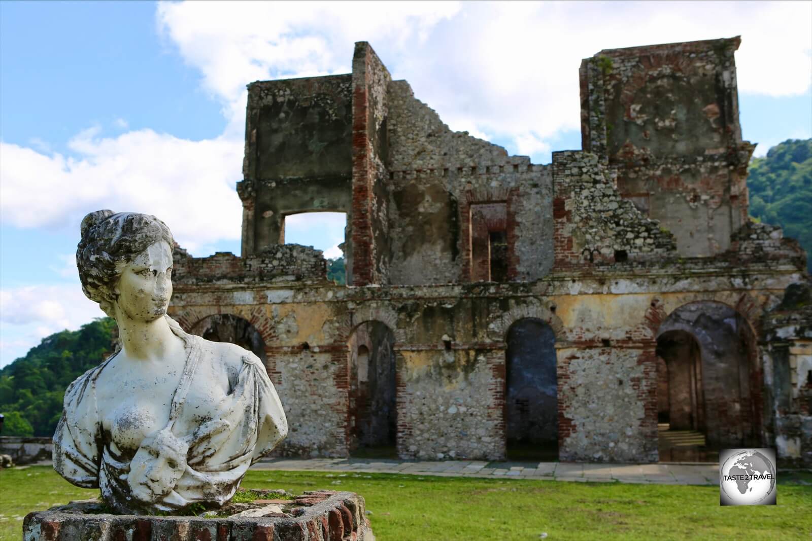
One of 15 Italian-marble statues which once adorned the garden at San-Souci palace.
Pre-Colombian History
The original inhabitants of Hispaniola were the native Taino Indians, an Arawak Indian race from present day Venezuela. The Taino called the island ‘Ayiti‘ (land of high mountains). These were the people Christopher Columbus first made contact with in 1492 when he landed on the island. At the time of European contact, the Taino’s inhabited all of the Greater Antilles islands and were battling against the more aggressive Carib Indians who had managed to conquer all of the Lesser Antilles islands. When Columbus arrived, the island was inhabited by hundreds of thousands of Taino people but the population declined rapidly, due to diseases brought by the Europeans.
Colonial History
Columbus originally called the island ‘La Española’, meaning The Spanish Island. Later translations altered the name to Hispaniola. Columbus claimed Hispaniola for Spain and returned a year later (1493) on his second voyage to establish the first Spanish colony – La Isabela – on the northeast shore of the island. La Isabela nearly failed because of hunger and disease, which prompted the Spanish authorities to develop a new colony at present day Santo Domingo (Dominican Republic).
Originally the Spanish claimed ownership of the whole of Hispaniola but they settled mainly in the east, in what is now the Dominican Republic. The west of the island (present day Haiti) was left largely empty until the French arrived in the 17th century and started a settlement on Tortuga island. Once this toehold had been established, the French founded larger settlements on Hispaniola. The Spanish resisted these moves and battled against the French. A resolution was agreed upon in 1697 with the Spanish and French signing the Treaty of Ryswick – this gave France the western 1/3 of the island and Spain the eastern 2/3’s.
Through the development of sugar and coffee plantations, the French colony of Saint-Domingue flourished, becoming one of the wealthiest in the Caribbean. African slaves were brought in large numbers to work the vast plantations. Work conditions for slaves in Haiti were harsh as the work was intensive. The French imported an enormous slave labour force, which ultimately outnumbered the French planters 10 to 1.

The UNESCO-listed old town of Cap-Haïtien.
Founded in 1711, the northern city of Cap-Haïtien served as the capital of Saint-Domingue. Today, the UNESCO-listed old town has a wealth of French colonial architecture, which has been well preserved.
By 1791, there were 500,000 slaves in Haiti, vastly outnumbering the white population. Inspired by the French Revolution, the slaves staged a revolt, burning many plantations to the ground and killing many whites. The revolution lasted 13 years and only ended once most of the whites had been evicted from the island (many fled to neighbouring Cuba and to New Orleans).
During and after the Haitian Revolution, many craftsmen from Cap‑Haïtien, who were free people of colour, fled to French-controlled New Orleans as they were under attack by the mostly African slaves. As a result, the two cities share many similarities in styles of architecture. Especially notable are the gingerbread houses lining the city’s older streets.

Piles of cannon balls outside Citadelle Laferrière, which was built by King Henri I.
Haiti became the first black republic in 1804, one with a constitutional prohibition against white people owning land. After independence any remaining whites were killed and whites were banished from the island for many decades after the revolution.
Following the revolution, France imposed a huge indemnity on Haiti, forcing the small nation to pay the equivalent of US$12.7 billion (2014 dollars) to France for lost property due to the revolution.
The first president of Haiti was Jean-Jacques Dessalines. Despite evicting the French, Dessalines modelled himself after the French Emperor Napoleon Bonaparte. He proclaimed himself Emperor Jacques I. Two years after coming to power, two of his own advisers, Henri Christophe and Alexandre Pétion helped provoke his assassination.
Christophe and Pétion divided the country into two rival regimes. In the north, Christophe created the Kingdom of Haiti (an authoritarian state where slavery was replaced by an oppressive serfdom). In the south, Pétion established the Republic of Haiti, breaking up former colonial estates and parcelled out the land into small holdings.
In 1811, Christophe proclaimed himself King Henri I and commissioned several extraordinary buildings, including Sans-Souci Palace and Citadelle Laferrière (see ‘Milot‘ section below). The new King Henri I, created a nobility class in the fashion of European monarchies and lived largely a European lifestyle, complete with impressive European-style palaces. In 1820, weakened by illness and with decreasing support for his authoritarian regime, he killed himself with a silver bullet. The two Haitis were then reunited with the government from the south ruling the country until 1843.
In the following years, Haiti was marred by instability, chaos, political power struggles, bloodshed and coups d’état. Since its revolution, Haiti has had at least 32 coups.
Modern Haiti
The constant lack of government and civil unrest led to a U.S. occupation, which lasted from 1915 to 1934. During their occupation the U.S. managed to restore order and developed extensive infrastructure. However the Haitians resented the occupation of their country. The withdrawal of the Americans in 1934 left a power vacuum that was filled by Haitian military elites.
The following 20 years saw further instability, turmoil and ruthless power struggles. This ended with the ascension of François (Papa Doc) Duvalier. Duvalier’s brutal dictatorship lasted nearly thirty years. Upon his death in 1971 his son, Jean-Claude (Bébé Doc) Duvalier, assumed power. The dictatorship of Bébé Doc ended when he was ousted in 1986.
A period of bloodshed, military rule and instability ensued. Peace finally returned with the election in 1990 of former priest, Jean-Bertrand Aristide.

A ‘Tap-Tap’ in Port-au-Prince.
Peace was short-lived and following a coup, Aristide went into exile. Most of his term was usurped by a military takeover, but – with help from the U.S. government – a deal was negotiated with the military elite and he returned to office in 1994. Aristide won a second term as president in 2000, and took office early in 2001. However, accusations of corruption were followed by a paramilitary coup that ousted Aristide in 2004.
Since 2004, Haiti has been occupied by UN peacekeeping troops (MINUSTAH). The current population of Haiti is roughly 7,500,000, with another 1,000,000 Haitians living abroad.
Flag
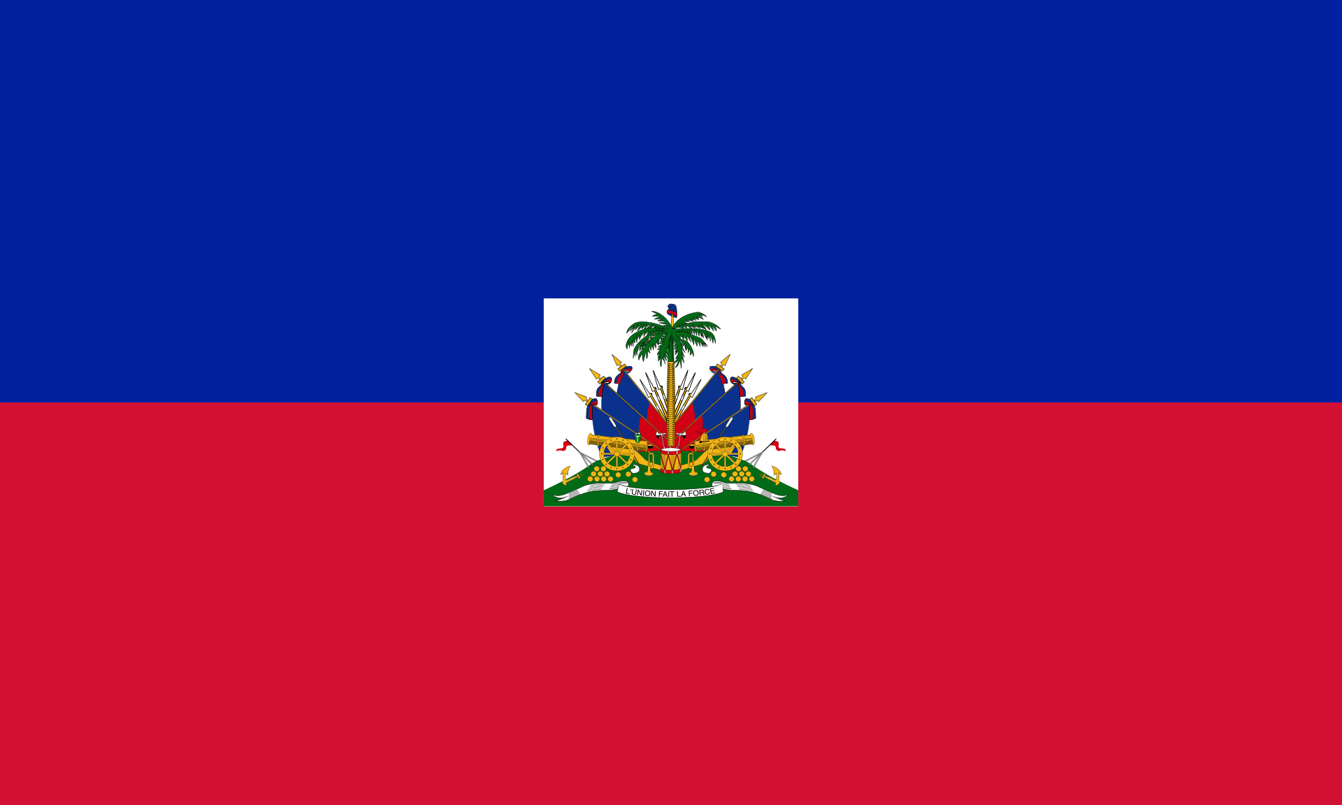
Flag of Haiti.
The flag of Haiti is a bi-colour flag featuring two horizontal bands coloured blue and red, with a white panel at the centre, bearing the national coat of arms. The coat of arms depicts a trophy of weapons atop a green hill and a royal palm, symbolising independence.
Did you know?
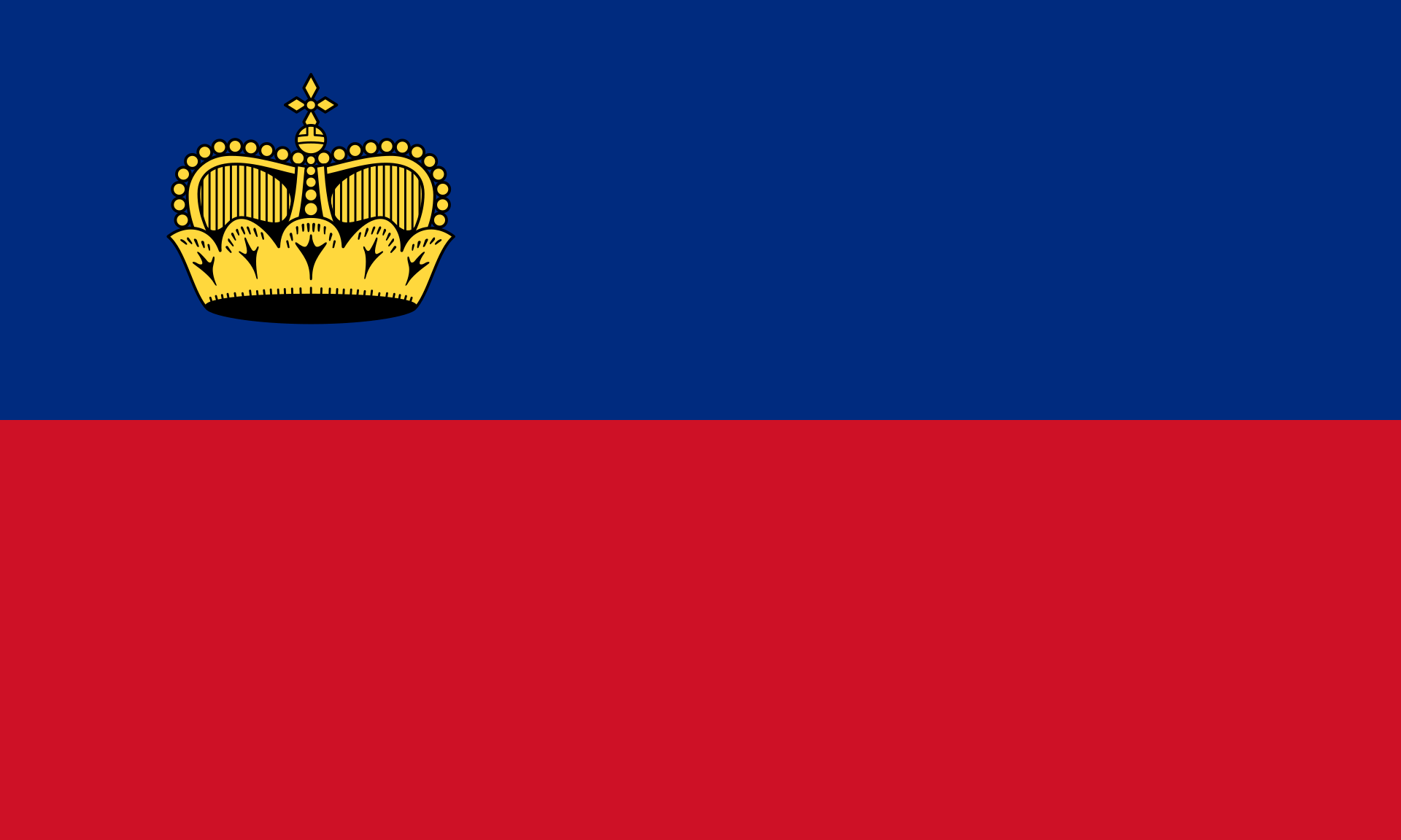
The Liechtenstein Flag.
The flags of Haiti and Liechtenstein were once identical. It was discovered at the 1936 Summer Olympics in Berlin that Haiti and Liechtenstein were using the same flag. This led to the addition of a crown to the design of the flag of Liechtenstein. The coat of arms is only used on the national flag of Haiti, with the civil flag consisting solely of the two un-augmented horizontal bands.
Currency

The ‘gourde’ is the official currency of Haiti.
The official currency of Haiti is the ‘gourde‘ which has the international currency code of HTG. The currency, which is divided into 100 centimes, is issued by the Banque de la République d’Haïti.
Banknotes are currently issued in denominations of 10, 20, 50, 100, 250, 500 and 1,000 gourde, with images for all notes available on the website of the Haiti Central bank.
2010 Earthquake

Downtown PAP, destroyed in 2010 by a powerful earthquake.
On the 12th of January 2010, a devastating earthquake struck Haiti. The earthquake, measuring 7.0 on the Richter scale and with an epicentre 25-km west of the capital, affected three million people. The death toll from the quake (figures range from 100,000 to 316,000) was exacerbated due to pre-existing poverty and poor housing conditions.
The downtown area of the capital was devastated and has yet (2016) to be rebuilt. Whole city blocks in the downtown area are currently barricaded, the Presidential Palace is in ruin and there are few functioning services. The government of Haiti estimated that 250,000 residences and 30,000 commercial buildings had collapsed or were severely damaged. But life goes on and while most downtown shops were destroyed, those same shops have set up business outside on the footpath and street.

At the time of my visit, most of downtown PAP layed in ruin, five years after the 2010 earthquake.
Encircling the capital are huge slums, home to most of the inhabitants of this city. Port-au-Prince is about the size of Chicago, but most parts of the capital do not have a functioning sewer system.
Sightseeing
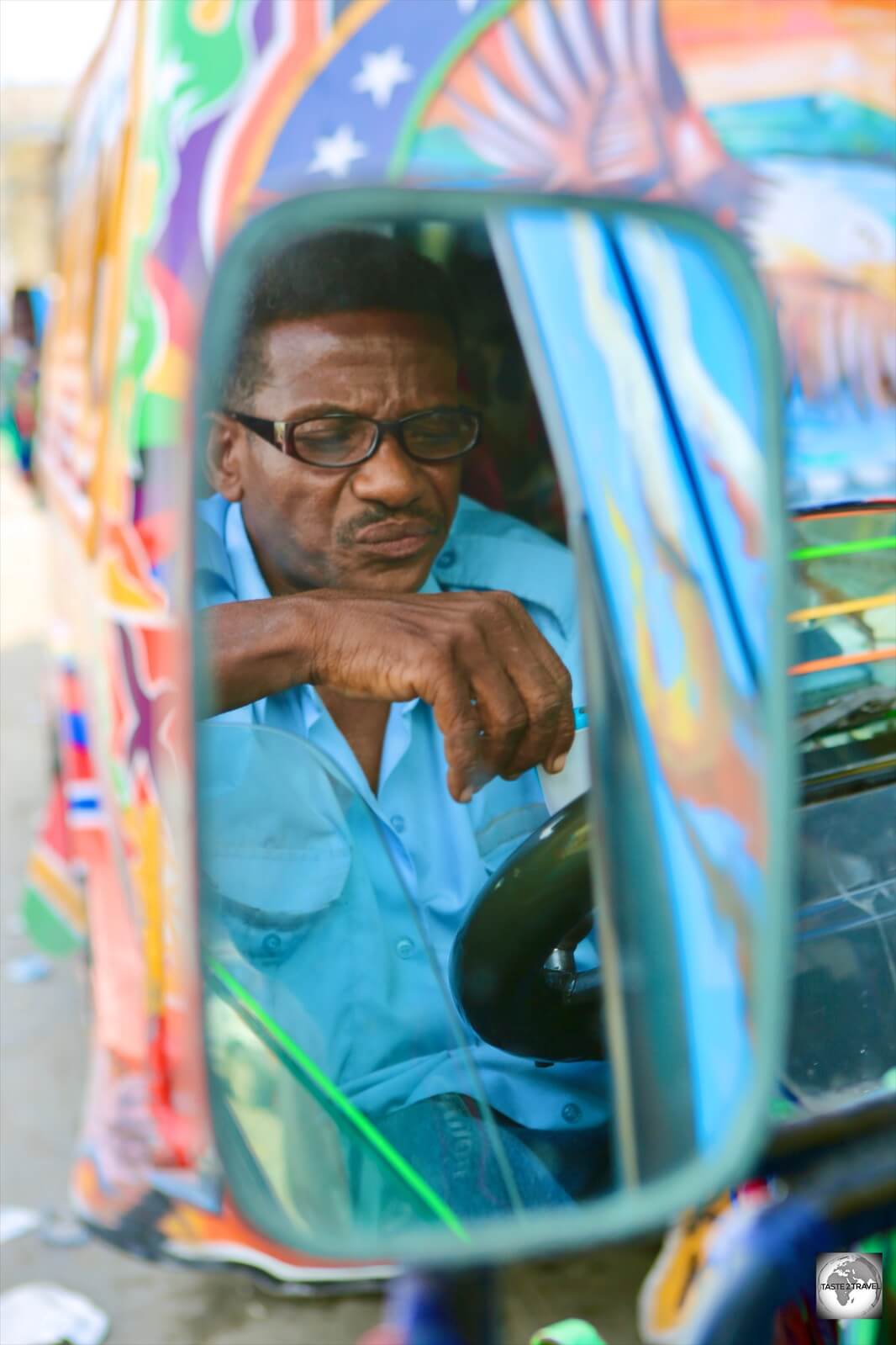
A ‘Tap-Tap’ (public minivan) driver in downtown PAP.
Port-Au-Prince
Port-au-Prince (PAP) was founded in 1742 during the boom years of French rule, when it was decided that the colony of Saint-Domingue needed a new central port. The capital was relocated from CAP to PAP.

A roadside bookshop in downtown PAP.
The city is located on the broad Golfe de la Gonâve and gets it’s name from the French ship Prince that had first moored there in 1706.
The exact population of the city is unknown due to the fact that most inhabitants live in large sprawling slums, which are constantly growing. It is believed up to half the population of the country (3,500,000) could be living in PAP.

A seller of fresh sugarcane in downtown PAP.
The wealthiest neighbourhood in town is the hillside Pétion-Ville. Here you will find the largest range of hotels, bars and restaurants in the city. Compared to the rest of the city, Pétion-Ville is reasonably safe but you should exercise caution in the evenings. This is the poshest neighbourhood in the country but anywhere else it would be described as ‘edgy’ and ‘gritty’.

A Mobile pharmacy, which is designed to be carried on the head of the vendor, Port-au-Prince.
The city is built in a basin around the bay with the commercial district located around the harbour and the residential neighbourhoods built on the slopes of the surrounding hillsides. The city was devastated by the earthquake in 2010 and has yet to be rebuilt. Most of the downtown area lacks any kind of services (sewage, electricity, running water) and many important buildings (Presidential Palace, National Assembly and Cathedral of Our Lady of the Assumption) are still in ruin.

Passport photos line the wall of a photo studio in downtown PAP.
Downtown PAP looks like a post-apocalyptic scene from a Mad Max film but some semblance of normalcy is slowly returning. The city is at once chaotic, exhilarating and compelling. Recovery from the earthquake is slow but the city is open to visitors and the staff at the city tourist information office are keen to see more tourists in town.
Sights of Port-au-Prince
Marche de Fer (English: Iron Market)

The Marche de Fer (Iron Market), Port-au-Prince.
This is the main market in town and features an iconic red metal edifice built in Paris in 1890 for a railway station in Cairo, Egypt. When the Egyptians cancelled their order the Haitian president (Florvil Hyppolite) purchased the structure and shipped it to Haiti. The market was devastated in the 2010 earthquake, but – being a building designated as historically important – it was renovated and re-opened 12-months later. It is one of the few functioning places downtown.
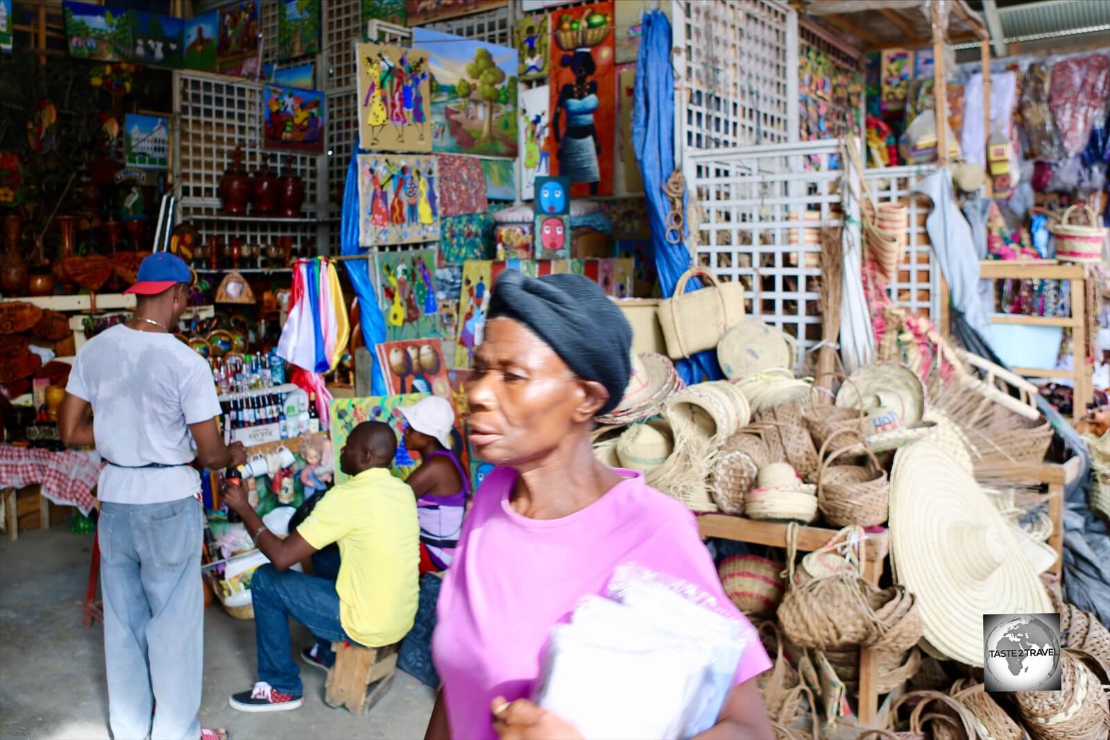
Shopping at the Marche de Fer in PAP.
Musée du Panthéon National Haïtien (MUPANAH)

The Musée du Panthéon National Haïtien (MUPANAH), Port-au-Prince.
MUPANAH provides an overview of Haitian history and culture and pays homage to the heroes of the independence movement. The onsite restaurant is the best in town (see the ‘Eating Out‘ section below).
Cathedral of Our Lady of the Assumption

The ruined ‘Cathedral of Our Lady of the Assumption’ in Port-au-Prince.
Often called Port-au-Prince Cathedral, the cathedral was built between 1884 and 1914, and was dedicated on December 13, 1928, becoming the cathedral church of the Roman Catholic Archdiocese of Port-au-Prince. The cathedral was destroyed in the 12 January 2010 earthquake.
Cap-Haïtien

Founded in 1711, Cap-Haïtien served as the capital of the French colony of Saint-Dominique.
With a population of 200,000, Cap-Haïtien (CAP) is the 2nd largest city in Haiti. The city is located on the north coast and was once known as the Paris of the Antilles. During the colonial period the city served as the capital of the French colony of Saint Dominque.
Did you know?
On the night before Christmas in 1492, the flagship of the explorer, Christopher Columbus, the Santa Maria, ran aground on a reef off the coast of present-day Cap-Haïtien.
Forced to abandon ship, Columbus and his men established the first Spanish settlement in the new world, La Navidad, 10 miles east of Cap-Haïtien.

The picturesque old town of Cap-Haïtien.
CAP has long had a reputation for being an incubator of independent thought and anti-establishment movements. In 2004, the city was taken over by militants who opposed the rule of the Haitian president Jean-Bertrand Aristide. They eventually created enough political pressure to force him out of office and the country.

A barber shop in the old town of Cap-Haïtien.
There is one main site to see in CAP and that is the old town itself. The historic centre has a wealth of French colonial architecture, which has been well preserved. The original craftsmen who built the houses in the old town of CAP fled to French-controlled New Orleans during and after the Haitian revolution, hence the two cities share many similarities in styles of architecture.

Rainbow over a heavily polluted beach in Cap-Haïtien.
At the centre of the old town is the main square which is dominated by the Cathedral Notre-Dame of Cap‑Haïtien.

Notre-Dame Cathedral, CAP
Milot
Nineteen kilometres from CAP is the town of Milot. Milot served as Haiti’s first capital under the self-proclaimed King Henri Christophe, who ascended to power following the revolution in 1807. He constructed the impressive Sans-Souci Palace in Milot and the massive Citadelle Laferrière atop a nearby mountain.
Both sites were added to the UNESCO World Heritage list in 1982, with UNESCO describing the two complexes as “one of the most remarkable attractions in the Western Hemisphere”
Sans-Souci Palace

The ruined, Sans-Souci palace, which is located in the town of Milot.
Located in the town of Milot, Sans-Souci Palace was the royal residence of King Henri I of Haiti (aka Henri Christophe). It was the most important of nine palaces built by the king. Construction of the palace started in 1810 and was completed in 1813. King Henri was known for his ruthlessness and an unknown number of labourers died building the palace.
The impressiveness of Sans-Souci was part of Henri Christophe’s program to demonstrate to foreigners, particularly Europeans and Americans, the power and capability of the black race. One American visitor described the palace as “having one of the most magnificent edifices of the West Indies.”

Local boys playing among the ruins of Sans Souci Palace.
During King Henri’s reign the palace was the site of opulent feasts. The palace featured extensive gardens, fountains and statues but was destroyed in 1842 by an earthquake.
The easiest way to reach the palace is by taxi or ‘tap-tap’ from CAP.
Citadelle Laferrière

The impressive hilltop Citadelle Laferrière, near Cap‑Haïtien.
Another of King Henri’s grand projects, Citadelle Laferrière is a large mountaintop fortress located 27-km south of CAP and 8-km from Milot. It has the distinction of being the largest fortress in the Americas.
The fortress was built by 20,000 workers between 1805 and 1820 as part of a system of fortifications designed to keep the newly independent country safe from French incursions.

Panoramic views from Citadelle Laferrière.
The fortress was outfitted with an impressive arsenal of 365 cannons of varying size. Enormous stockpiles of cannonballs still sit in stacks at the base of the fortress walls. Since its construction, the fortress has withstood numerous earthquakes, though a French attack never came and it was eventually abandoned.

The steep and windy path which climbs to Citadelle Laferrière.
The easiest way to access the fort is to take a motorbike taxi from Milot to the car park at the base of the mountain. The ride along the steep cobbled road, which winds its way up the mountain is a teeth-jarring one. From the ticket office a steep access path winds its way up to the fort (elevation 910-m). You can either walk from the car park (like exercising in a sauna) or pay to ride a horse.

A panoramic view of the north coast of Haiti from Citadelle Laferrière.
Accommodation

My spacious room at the NH Haiti El Rancho hotel in Petion-Ville, Port-au-Prince.
In PAP I treated myself and stayed at the amazing NH Haiti El Rancho hotel in Pétion-Ville. This is a true oasis of calm in an edgy city. I secured a discount rate using booking.com
In Cap-Haïtien I stayed on the outskirts of town at Auberge Villa Cana. I would not recommend staying here. Service is terrible, staff are unfriendly and disinterested and the hotel is located in a remote location on the outskirts of the city. There are better options downtown.
Eating Out
The cuisine of Haiti is a blend of several culinary styles including French, African, Taino and Spanish. The cuisine is comparable to that of creole cooking, unpretentious and simple but with bold and spicy flavours.
Dining options are limited. Downtown PAP was destroyed in the 2010 earthquake and most buildings are still in ruin.
One of the best dining options downtown is Les Jardins du MUPANAH, located on the grounds of the recently re-developed MUPANAH (Musée du Panthéon National Haïtien).
There are several popular dining options in Pétion-Ville and this is the safest neighbourhood to be out in after dark, although you need to be very vigilant. If you are in the mood for fine Lebanese cuisine, you should head to Magdoos (30 Rue Oge). The tabbouleh, hummus, kebabs and cocktails are the best in town.
Visa Requirements
Most nationalities do not require visas for Haiti – check your visa requirements prior to arrival.
Getting There
By Air
There are two international airports in Haiti:
- Toussaint L’Ouverture International Airport serving Port-au-Prince
- Cap-Haïtien International Airport serving Cap-Haïtien
The following airlines provide international connections to Port-au-Prince:
- Air Canada Rouge – services to Montréal (Trudeau)
- Air Caraïbes – services to French Guiana, Martinique, Paris (Orly), Guadeloupe, Dominican Republic (Santo Domingo), St. Maarten
- Air France – services to Miami, Guadeloupe
- Air Transat – service to Montréal (Trudeau)
- American Airlines – services to Fort Lauderdale, Miami, New York (JFK)
- Copa Airlines – service to Panama City
- Delta Air Lines – service to Atlanta
- Insel Air – services to Curaçao, Miami, St. Maarten
- InterCaribbean Airways – services to Jamaica (Kingston), Providenciales, Dominican Republic (Santo Domingo)
- JetBlue Airways – services to Fort Lauderdale, New York–JFK, seasonal service to Boston
- Spirit Airlines – services to Fort Lauderdale
- Sunrise Airways – services to Dominican Republic (Santiago de los Caballeros), Dominican Republic (Santo Domingo), Jamaica (Montego Bay), Bahamas (Nassau), Cuba (Camagüey), Cuba (Santiago de Cuba)
The following airlines provide international connections to Cap-Haïtien:
- American Airlines – service to Miami
- InterCaribbean Airways – service to Providenciales
- IBC Airways – services to Fort Lauderdale, Miami, Nassau
- SALSA d’Haiti – service to Port-au-Prince
- Sunrise Airways – service to Port-au-Prince
By Sea
There are no scheduled international ferry services from Haiti.
By Road
There are daily international bus connections between PAP and Santo Domingo (Dominican Republic). These are run by the following companies:
- Caribe Tours – Dominican company which runs two buses a day from its terminal in Pétion-Ville.
- Capital Coach Line – Haitian company which runs buses from three terminals in PAP – 102 Route Frere, Pétion-Ville, Tabarre Blvd (next to the U.S. Embassy)
There is one daily international bus connection between Cap-Haïtien and Santiago (Dominican Republic) then onto Santo Domingo (Dominican Republic). This service is run by:
- Caribe Tours – Dominican company which runs one bus a day from it’s terminal in downtown Cap-Haïtien.
Getting Around
Tap-Tap

A ‘Tap-Tap’ in Port-au-Prince pays tribute to Nelson Mandela.
The most common form of public transportation in Haiti are the brightly painted pickup trucks called ‘tap-taps‘. They are named this because when a passenger needs to be let off they use their coin money to tap the side of the vehicle. You will find these in all urban areas. They don’t run to any fixed timetable and pick up and drop off on request.
Buses
Buses are the best option for getting around the country. Security is an issue with robberies occasionally occurring on the main highway – RN-1.
The journey time from PAP to CAP is 7-hours, I travelled with Blue Sky Logistics who operate comfortable, safe buses.
Taxis
Taxis in Haiti are run by private companies and individuals. There are no meters, fares are negotiated before the journey and are expensive. A good, reliable company in Pétion-Ville is Nick’s Taxis (Tel: +509 29 48 7777).
Car
There are rental agents located at the airport in PAP and downtown in Pétion-Ville. Driving in PAP and CAP is best described as erratic and dangerous – not for the faint-hearted.
That’s the end of my Haiti Travel Guide.
Safe Travels!
Darren
Follow me on Instagram:

Further Reading
Other travel reports from the Caribbean region include:
- Anguilla
- Antigua & Barbuda
- Aruba
- Bahamas
- Barbados
- Bonaire
- Bermuda
- Cayman Islands
- Cuba
- Curaçao
- Dominica
- Dominican Republic
- Grenada
- Guadeloupe
- Haiti
- Jamaica
- Martinique
- Montserrat
- Puerto Rico
- Saba
- Saint Barthélemy (Saint Barts)
- Saint Eustatius (Statia)
- Saint Kitts & Nevis
- Saint Lucia
- Saint Martin/ Sint Maarten
- Saint Vincent & The Grenadines
- Trinidad & Tobago
- Turks & Caicos
- Virgin Islands (British)
- Virgin Islands (U.S.)
Haiti Travel Guide Haiti Travel Guide Haiti Travel Guide Haiti Travel Guide Haiti Travel Guide Haiti Travel Guide Haiti Travel Guide Haiti Travel Guide Haiti Travel Guide Haiti Travel Guide
Author: Darren McLean
Darren McLean is an Australian full-time digital nomad who has spent 36 years on a slow meander around the globe, visiting all seven continents and 239 UN+ countries and territories.
He founded taste2travel to pique one’s curiosity and inspire wanderlust.


