
Saint Kitts & Nevis Travel Guide
Welcome to the taste2travel Saint Kitts & Nevis Travel Guide!
Date Visited: April 2015
Introduction
The Federation of Saint Kitts and Nevis is a two-island country. It’s part of the Leeward Islands, which are a part of the Lesser Antilles.
It’s located southeast of the islands of Sint Eustatius (Dutch), Saba (Dutch) and south of the islands of Sint Maarten/ Saint Martin (Dutch/ French), Saint Barthélemy (French) and Anguilla (British). It’s located west of Antigua & Barbuda and northeast of Montserrat (British).
Location
Saint Kitts and Nevis
Saint Kitts and Nevis
It’s the smallest sovereign state in the Americas, in terms of area (270 square km) and population (54,000). The population is mostly comprised of Afro-Caribbean’s who are descendants from former slaves.
Despite its small size, St. Kitts has played a big part in the European settlement of the Caribbean.

Vervet monkeys were introduced to St. Kitts from Africa more 300 years ago.
History

A view from Brimstone Hill fortress on St. Kitts.
The first settlers to arrive on the islands (3,000 B.C) were an archaic people from Florida (USA). As with every other island in the region, they were eventually replaced by the peaceful Arawak’s, who migrated north from present day Venezuela. The Arawak’s were replaced by the more aggressive Caribs. It was the Caribs whom the Europeans met when they first arrived.
Saint Kitts and Nevis were among the first islands in the Caribbean to be settled by Europeans. The first European to make landfall in 1493 was – no surprise – Columbus during his second voyage to the Americas.
Columbus originally named the island Sant Jago (St. James) but early Spanish explorers confused the island with neighbouring Saba, then labelled on maps as ‘San Cristobal’ or Saint Christopher. The name has stuck ever since.
In the 17th century, a common British nickname for Christopher was Kit, or Kitt. The British used this name for the island and it remains in use today.
The Spanish never settled on St. Kitts, instead the first Europeans to settle on the island were French Huguenots in 1538. The Spanish were not happy with the French move so they eventually returned and destroyed the settlement, expelling its inhabitants.
The British settled on the island in 1623. The French then returned and an arrangement was made between the two, whereby the British would control the centre of St. Kitts and the French would control either ends of the island. Saint Kitts was home to the first British and French colonies in the Caribbean.
The British used St. Kitts as their base to settle the islands of Antigua, Montserrat, Anguilla and Tortola (British Virgin Islands).
The French used St. Kitts as their base to settle the islands of Martinique, Guadeloupe and Saint Barthélemy. The French established Basseterre as their capital on St. Kitts and later designated it as the capital for the entire French West Indies.
During the 17th century the British and French continuously battled each other for control of the island. After a decisive British victory over the French at Brimstone Hill in 1782, the French ceded the island to Britain. The British maintained control until independence in 1983.

A golden sunset, South Friars beach on St. Kitts.
Historically St. Kitts and Nevis (despite being separated by a narrow channel) were always governed as separate independent entities until they were forced into a union in the 19th century by Britain.
Rivalries still remain today with Nevis accusing St. Kitts of neglect. In past referendums a majority of Nevians voted for secession from the federation, but they have never reached the 2/3 majority mark which would allow this to happen.
Eastern Caribbean Central Bank

The Eastern Caribbean Dollar.
The official currency of St. Kitts and Nevis is the Eastern Caribbean dollar.
Headquartered in Basseterre, the Eastern Caribbean Central Bank (ECCB) is the monetary authority for the following Caribbean nations:
- Antigua & Barbuda
- Grenada
- St. Kitts & Nevis
- Dominica
- St. Lucia
- St. Vincent and the Grenadines
and the following British overseas territories:
- Anguilla
- Montserrat
The bank was founded in 1983 in order to maintain the stability of the Eastern Caribbean Dollar (EC$) and the integrity of the banking system of the member states.
The bank issues the Eastern Caribbean Dollar (EC$), which is the currency of the member states. Since 1976, the exchange rate has been pegged to the US$ at a rate of US$1 = EC$2.70.
Flag
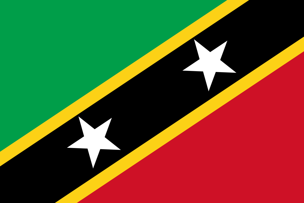
Saint Kitts and Nevis Flag
The flag of Saint Kitts and Nevis consists of a yellow-edged black band containing two white stars that divides diagonally from the lower hoist-side corner, with a green upper triangle and red lower triangle.
Designed in the early 80’s by a student, Edris Lewis, the colour green alludes to the country’s fertile land, while the red evokes the fight for freedom against slavery and colonialism. The yellow stripes represent ‘sunshine’, while the black epitomises the people’s African origins and the two white stars symbolise hope and liberty.
Sightseeing
St. Kitts – Basseterre

A view of Basseterre from my Winair flight to St. Martin.
The capital and largest city (population: 13,000) of St. Kitts & Nevis, Basseterre is a port city located in a valley surrounded by mountains. Founded in 1627 by the French, it is one of the oldest towns in the Eastern Caribbean. The French named it ‘Basseterre’ (low land) due to its valley setting. It served as the capital of the French colony of Saint-Christophe, which consisted of the northern and southern extremities of the island of St. Kitts. At this time Britain controlled the central portion of the island. At one point Basseterre was made the capital of the entire French West Indies, which included the islands of Guadeloupe and Martinique.
In 1727 the British took full control of the island and Basseterre was made capital of the entire island. Basseterre today is the home of the headquarters of the Eastern Caribbean Central Bank and a financial centre for the region. The city centre is compact and most sites can be covered on foot in a day.
Sites include:
Independence Square
Once the site of a slave market, the square was renamed when the island achieved independence from Britain. Today the square is a tranquil oasis in the bustling city centre.
The Circus

Named after London’s Piccadilly circus, ‘The Circus’ is the centre of Basseterre.
The landmark in Basseterre, the Circus is a round-about with an ornate clock tower at its centre. The cafes overlooking the Circus are a good place to sit and relax and watch the world go by.
St. George’s Anglican Church
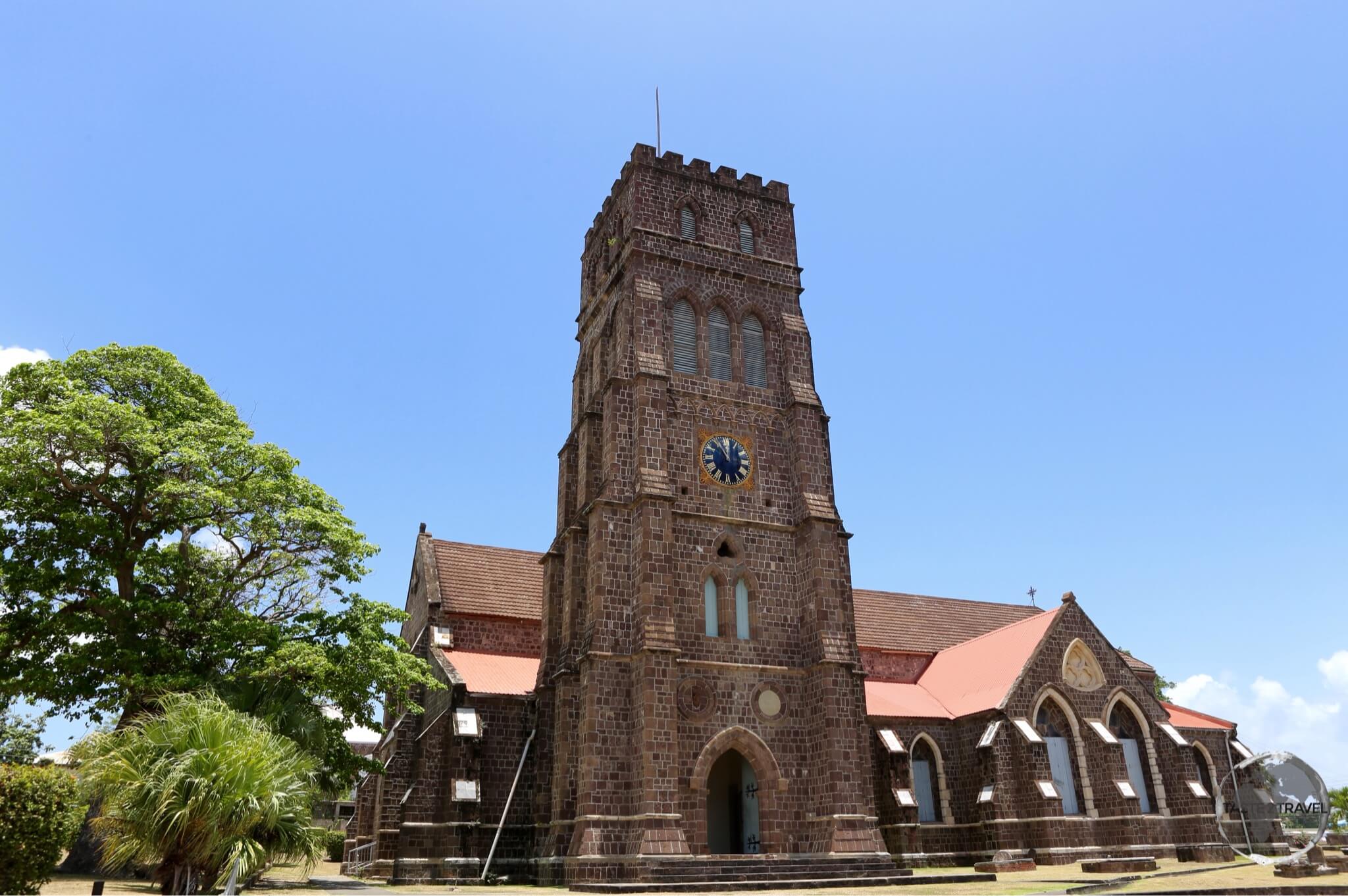
The historic St. George’s Anglican Church in Basseterre.
The French built the first church on this site in 1670. This was later destroyed by the British. Since then a number of churches have been built but have been destroyed by either fire, earthquakes or hurricanes. The current church was consecrated in 1859.
Co-Cathedral of Immaculate Conception
One of the tallest structures in Basseterre. Worth 5 minutes of your time.
National Museum
Housed in the old treasury building, this small museum contains an interesting collection of exhibits explaining the history of the island.
My favourite cafe downtown is the Gallery Cafe. The cafe is housed in a beautiful old wooden building on the north side of Independence square. The cafe is owned by Leah – a friendly and enthusiastic British expat. The coffee here is very good as is the food. There are artworks from local artists available for purchase.
St. Kitts – Around the Island
If you drive in a clockwise direction around the island from Basseterre, you will cover the following sites in the same order.
Bloody Point
On the road to Romney Manor you will pass Bloody Point. This was the sight of the Carib massacre of 1626.
The Caribs were afraid that the number of European settlers on the island was increasing so they devised a plan to massacre them. The British were told in advance of the plan and together with the French decided to strike first.
They launched a surprise attack, massacring around 3,000 natives, enough that the river here was said to flow red with blood for 3 days after the massacre, hence the name. The site of the massacre is marked with a simple white cross.
Romney Manor

The 350-year-old Saman tree at Romney Manor.
Owned and managed over the centuries by successive Earls of Romney, this 17th-century sugar estate once belonged to the great-great-great-grandfather of Thomas Jefferson (3rd President of USA).
It is believed that Tegereman, the Carib Indian Chief, once had his village on this site.
The manor sits on a hill in among lush gardens with panoramic views over the sea. The entrance to the manor is dominated by a huge 350-year-old Saman tree. On the way up to the manor you can visit the ruins of the old sugar mill.
The manor is now the home of Caribelle Batik, which sells handmade batik wraps, dresses and other items.

Colourful batik drying at ‘Caribelle Batik’ whose workshop is located at Romney Manor.
Brimstone Hill Fortress
Set on an impressive hill at an elevation of 243-m overlooking the Caribbean sea, Brimstone Hill Fortress National Park is a UNESCO World Heritage Site. It is the site of one of the most impressive forts in the Caribbean.
Begun in the 1690’s, the fort was built over a period of 100 years by British military engineers using slave labour. The entire fortress has been constructed using the hard volcanic rock of which the hill is composed.

View of St. Kitts from Brimstone Hill fortress with the Dutch island of Statia in the background.
From the fort you have panoramic views of the coastline of St. Kitts, the Caribbean sea, the township of Sandy Point, and the neighbouring Dutch island of Statia.

St. Johns Anglican Church at Belle Vue on the north coast of St. Kitts.
Dieppe Bay Town
Settled in 1538, Dieppe Bay Town is the oldest town founded by Europeans in the Eastern Caribbean. The Atlantic ocean and Caribbean sea converge here. There is good snorkeling just offshore.
Ottley’s Plantation Inn
This restored 18th-century sugar plantation is now a luxury inn and is located on a hill overlooking the east (Atlantic) coast of the island, 13-km from Basseterre.
The inn is set among lush gardens and provides access to a small rain forest where you can see vervet monkeys. The restaurant is especially good for lunch – see the ‘Eating Out‘ section below for more details.
South of Basseterre

A view of the isthmus and peninsula at the southern end of St. Kitts. Nevis peak is in the distance.
South of Basseterre, lies a thin isthmus, which joins the main part of the island to a peninsula. Here you will find the best beaches on the island. Many of these beaches are currently secluded but development is underway with giant resorts being constructed or in the planning stages.
Most of the beach at Kittian Village is occupied by the sprawling Marriott resort but is fully accessible to the public. The sand on this side of the isthmus is golden yellow.
Across on the opposite side of the isthmus lies Frigate Bay, which is actually two bays located close together. The sand on this side of the isthmus is grey. Frigate bay is popular with Basseterre locals, with a number of beach bars and restaurants offering drinks and dinner.
Further south is South Friars Bay, another grey-sand beach. The highlight here is sunset drinks at the Ship Wreck Beach Bar and Grill – (See the ‘Eating Out‘ section below for more details). There is good snorkeling just offshore.
Added entertainment is provided by some wild vervet monkeys and ferrets who are fed scraps from the restaurant kitchen.

A view of South Friars beach on St Kitts.
Further south is the upscale development of Christophe Harbour, which includes a marina and an expensive waterfront bar – Salt Plage. For those who like to sip ‘signature’ cocktails while watching the sunset.
A new luxury Hyatt resort is scheduled to open in 2016 at Banana Bay, which is located at the end of the peninsula, overlooking the ‘narrows’ and Nevis.

A sea gull on St. Kitts.
Nevis – Charlestown
At 93 square kilometres, Nevis is small. There is a single road which follows the coast around the island, which could be driven in under two hours. Nevis lies just 3-km across a shallow channel from St. Kitts. The channel is known as “The Narrows”. Regular ferries connect the two islands.

The sea-bridge ferry connects St. Kitts to Nevis (background).
The island was formed by a now dormant volcano – Nevis Peak, which lies at the centre of the island.
Like St. Kitts, the beaches on the island are composed of a mixture of white coral sand mixed with brown and black sand, which is eroded and washed down from the volcanic rocks that make up the island.
The name, Nevis, is derived from the Spanish, Nuestra Señora de las Nieves, so named because the white cloud that usually covers the top of Nevis Peak reminded the Spaniards of the ancient Catholic miracle ‘Our Lady of the Snows’.
Horatio Nelson was once stationed on Nevis, he met and married a Nevisian, Frances Nisbet, the young widow of a plantation-owner.
The island has a population 12,000, mostly descendants of former African slaves.
Charlestown is the capital and largest city (population: 1,538) of Nevis. Frequent ferries connect Charlestown with Basseterre – see the ‘Getting Around‘ section below for more details. There is not much to see in this tiny village but it is a nice place to meander for an hour or two.
Charlestown was the birth place of Alexander Hamilton – who would later become a chief aide to General George Washington and was one of the founding fathers of the United States of America.
Sites to see:
Museum of Nevis
This museum provides an overview of the history of Nevis. The birthplace of Alexander Hamilton is next door.
Memorial Square

Memorial Square in Charlestown, the charming capital of Nevis.
A nice shady square where you can relax and watch the world go by. The square is lined with beautiful old stone colonial buildings, including the courthouse and library.
Market Place
A small covered market where you can purchase local produce.
Nevis – Around the Island
Like St. Kitts, there is one road which follows the coast around this circular island. It’s impossible to get lost. If you drive without stopping you could see the entire island in under 2 hours.
Driving in a clockwise direction from Charlestown, you will pass:
Pinney’s Beach
Directly north of Charlestown, this is a nice sandy stretch of beach on the protected leeward (Caribbean) side of the island. Its a popular beach and can get busy.
Cades Bay
This quiet bay, which has a beautiful beach, is the terminal for the Seabridge vehicle ferry.
On the main road you will find Mansa’s Last Stop, a corner store, which stocks local produce. It is owned by Mervin “Mansa” Tyson, who is passionate about his fruits and vegetables, which he grows himself.
Lovers Beach
At the top of the island you will find this picture postcard beach of white sand and turquoise waters.
Vance W. Amory International Airport
Nevis’s international airport is located at the top of the island – see the ‘Getting There‘ section for more details.
Newcastle
In the village of Newcastle you will find Newcastle Pottery, where local artisans create unique pieces using generations-old techniques. A red clay, which is native to the island, is used to produce each hand-worked piece – there are no pottery wheels in use here.
Golden Rock Inn

The beautiful garden at the Golden Rock Inn on Nevis.
Located just beyond the village of Mannings, as the road sweeps away from the coast, you will find the Golden Rock Inn. The beauty and serenity of this place is magical. If you are on the island, you simply have to visit.
The inn is located on a hill with panoramic views of the Atlantic coast and ocean. It’s surrounded by lush gardens and the ruins of an old sugar mill. You should time your visit during a mealtime, the food in the restaurant is divine. For more on the restaurant see the ‘Eating Out‘ section below.

The garden at the Golden Rock Inn on Nevis.
Accommodation
There are lots of options on both St. Kitts and Nevis. I stayed on St Kitts at the Royal St. Kitts Hotel, which is located in the Kittian Village neighbourhood. This neighbourhood is ideal as it offers easy access to Basseterre (10 min drive), to the beaches at the southern end of the island and all the bars, cafes and restaurants in the village.
Best to book in advance using booking.com
Eating Out
Agriculture on both islands is abundant due to the rich volcanic soil. Local produce can be purchased at the markets in Basseterre or Charlestown.
Restaurant menus feature typical West Indian classics such as goat stew, which includes breadfruit and green papaya in a tomato-based stew. Seafood is also abundant.
St. Kitts
On St. Kitts, the restaurant at Ottley’s Plantation Inn serves up gourmet cuisine all within the old stone walls of the former sugar factory. Its an ideal place to stop for lunch if you are exploring the island. The plantation is located off the main road, on the east coast, in the town of Ottley, 13-km from Basseterre.
South of Basseterre is the tourist enclave of Kittian Village (home to the sprawling Marriott resort). Here you will find restaurants, bars and cafes. The best coffee in this neighbourhood is served at the Rituals cafe on the main road.
Nearby is Frigate bay, a nice sandy beach which is lined with beach bars and restaurants. Its especially lively in the evenings.
Further south on South Friars bay is the Ship Wreck Beach Bar and Grill. This place has a rustic ‘shipwrecked’ feel to it, with furniture made from bits of driftwood and other items found on the beach. This is an ideal place to watch the sunset while enjoying a happy-hour rum punch. There is a grey sand beach here and an offshore reef for snorkeling.
Nevis
For a memorable lunch on Nevis, it is hard to beat ‘The Rocks‘ restaurant, which is at the Golden Rock Inn. Everything at the inn, from the rooms, the garden and the food has been carefully considered. If you are looking for a special dining experience this is the place.
Located on the slopes of Nevis peak, 5-km from Charlestown, the restaurant serves Caribbean cuisine in a beautiful outdoor garden setting. The seafood is purchased from local fisherman, the produce from local farmers. The meals are full of flavour and the fresh fruit juices are divine. Its open for breakfast, lunch and dinner. Highly recommended.
Visa Requirements
Some nationalities require visas for St. Kitts & Nevis – check your visa requirements prior to arrival.
Getting There

View of the north coast of St. Kitts from my Winair flight to St. Martin.
By Air
St. Kitts
International flights to St. Kitts arrive at Robert L. Bradshaw International Airport, located on the northeast outskirts of Basseterre.
The following airlines provide international connections to Robert L. Bradshaw International Airport:
- Air Sunshine – flies to/ from Anguilla, Saint Croix, Saint Thomas, San Juan, Tortola
- American Airlines – flies to/ from Miami
- British Airways – flies to/ from Antigua, London-Gatwick
- LIAT – flies to/ from Antigua, Barbados, Sint Maarten, Tortola
- Seaborne Airlines – flies to/ from San Juan
- Trans Anguilla Airways – flies to/ from Anguilla, Antigua, Saint Eustatius
Nevis
International flights to Nevis arrive at Vance W. Amory International Airport, which is located in the northeast of the island, west of the village of Newcastle.
The following airlines provide international connections to Vance W. Amory International Airport:
- Air Sunshine – flies to/ from Saint Croix, Saint Kitts, Saint Thomas, San Juan, Tortola
- Cape Air – flies to/ from San Juan
- Trans Anguilla Airways– flies to/ from Anguilla
By Sea
Despite the fact that the neighbouring Dutch territory of Statia is just 11 km from the nearest point on St. Kitts – and clearly visible across the sea – there are no international ferry services linking St. Kitts and Nevis to any other island.
The only other way to arrive by sea is by private yacht or cruise ship.
Getting Around
Inter-Island Ferries

The Seabridge ferry from St. Kitts to Nevis.
There are frequent ferries, which make the short crossing across ‘the narrows’ between St. Kitts and Nevis. There is a vehicle ferry, which sails six times a day between St. Kitts (Mayors Bay) and Nevis (Cades Bay).
The 5-km crossing takes 15 minutes with the service operated by Seabridge Inc. The departure and arrival ports for this service are remote and taxis are not available. You should only use this ferry if you are travelling by car. Foot passengers should use the more convenient passenger ferry services, which sail between downtown Basseterre and downtown Charlestown.
A number of frequent passenger ferries operate between St. Kitts (Basseterre) and Nevis (Charlestown). Crossing time for the 12-km journey is between 30 to 45 minutes. Check the SKN Vibes website for all current ferry schedules.
Water taxis between the two islands are also available on demand.
Public Transport
The public transportation system on St. Kitts and Nevis is made up of privately owned mini-buses, which run according to demand and not a timetable. Buses stop and drop-off where ever required. Buses can be identified by their green license plates, which are all prefixed with a ‘H‘ or ‘HA‘.
Taxis
Taxis are available on both islands. You can identify them by their yellow license plates, which are all prefixed with a ‘T‘ or ‘TA‘.
Rental Car

A rental car is the best way to maximise your time on both St Kitts and Nevis.
The best option for exploring the island is to hire a car upon arrival at the airport. As with other Anglo-Caribbean countries, the government of St. Kitts and Nevis raises revenue by requiring anyone hiring a car to hold a temporary driving permit. This can be purchased at the car rental agency.
As with other Anglo-Caribbean islands, road signage is almost non-existent but there is just one road around the coastline of each island so its impossible to get lost.
At the time of my visit the government had a major road re-surfacing project underway on St. Kitts.
Safe Travels!
Darren
Follow me on Instagram:

Further Reading
Other travel reports from the Caribbean region include:
- Anguilla
- Antigua & Barbuda
- Aruba
- Bahamas
- Barbados
- Bonaire
- Bermuda
- Cayman Islands
- Cuba
- Curaçao
- Dominica
- Dominican Republic
- Grenada
- Guadeloupe
- Haiti
- Jamaica
- Martinique
- Montserrat
- Puerto Rico
- Saba
- Saint Barthélemy (Saint Barts)
- Saint Eustatius (Statia)
- Saint Lucia
- Saint Martin/ Sint Maarten
- Saint Vincent & The Grenadines
- Trinidad & Tobago
- Turks & Caicos
- Virgin Islands (British)
- Virgin Islands (U.S.)
Saint Kitts & Nevis Travel Guide Saint Kitts & Nevis Travel Guide Saint Kitts & Nevis Travel Guide Saint Kitts & Nevis Travel Guide Saint Kitts & Nevis Travel Guide Saint Kitts & Nevis Travel Guide Saint Kitts & Nevis Travel Guide Saint Kitts & Nevis Travel Guide
Author: Darren McLean
Darren McLean is an Australian full-time digital nomad who has spent 36 years on a slow meander around the globe, visiting all seven continents and 239 UN+ countries and territories.
He founded taste2travel to pique one’s curiosity and inspire wanderlust.


