Bonaire Travel Guide
Welcome to the taste2travel Bonaire Travel Guide!
Date Visited: March 2015
Introduction
When your plane pulls up outside the small terminal building of Bonaire’s Flamingo International Airport (painted Flamingo pink) you’ll know you’ve landed somewhere special.

Dutch-style buildings in downtown Kralendijk, the capital of Bonaire.
Located at the eastern end of the ‘ABC‘ (Aruba, Curaçao and Bonaire) island chain, Bonaire prides itself on being an environmentalists’ paradise.
The island has focused on preserving its nature beauty, with an emphasis on its stunning marine environment, and has over the years taken steps to accomplish this.
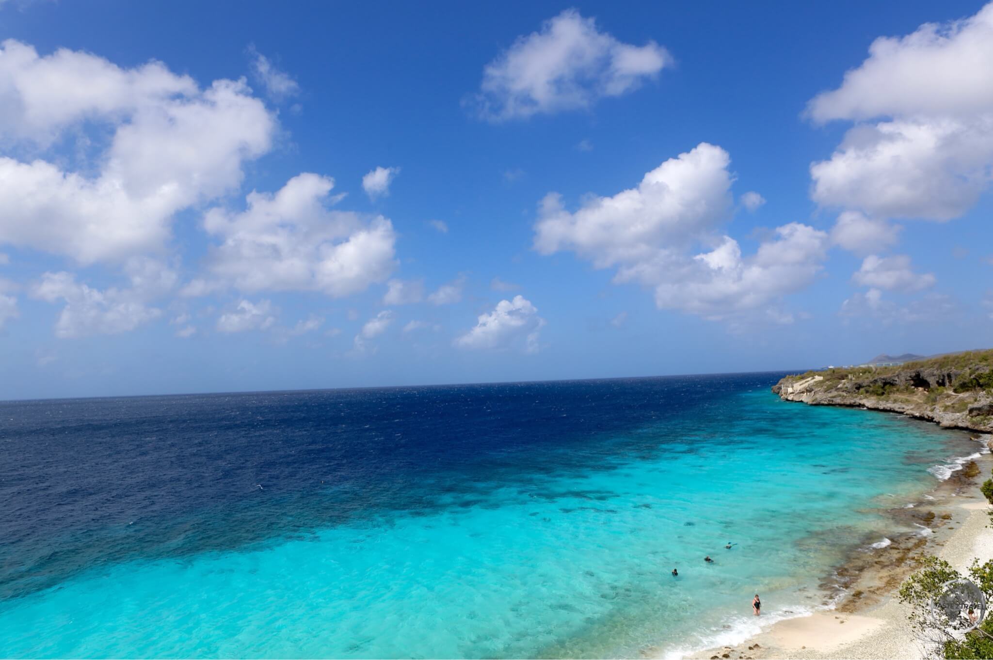
All the waters surrounding the island are 100% protected, which means this is a diver & snorkeler’s paradise!
Visiting cruise ships are forced to employ long ropes in order to tie up to the wharf rather than dropping anchor and damaging the pristine reef which runs along the entire west coast of the island.

Cruise ships at Bonaire are tied to the shore as they are not allowed to drop anchor on the protected reef.
There are 63 dive sites on Bonaire itself with an additional 26 on Klein Bonaire. Thanks to its constant trade winds, the island is also a popular destination for wind-surfing and kite-surfing, with most of the action taking place on the south-west coast.

The flag of Bonaire.
Even if you’re not a diver or windsurfer, Bonaire offers other attractions, such as Flamingo watching by the shores or Lake Gotomeer and sipping vodka produced from a cactus!
Location
The island lies 48-km east of Curaçao and 140-km east of Aruba. It is the smallest of the ABC islands in terms of population (16,500) and 2nd smallest in terms of area (38-km long, 8-km wide).
However, what the island lacks in size it makes up for in charm and soul. Bonaire is enchanting. A large number of visitors to the island are return visitors. It is also outside of the Caribbean hurricane belt.

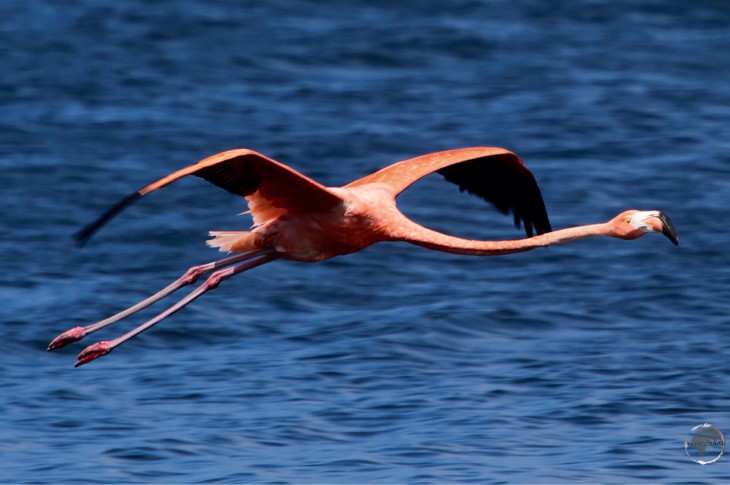
A Caribbean Flamingo on Lake Gotomeer.
History
The name Bonaire is thought to have originally come from the native Indian Caiquetio word ‘Bonay’, a name that meant low country. The early Spanish and Dutch modified its spelling to Bojnaj and also Bonaire.

An antique promotional poster for Bonaire.
While Curaçao emerged as a centre of the slave trade, Bonaire became a plantation of the Dutch West India Company. A small number of African slaves were put to work cultivating dye-wood and maize and harvesting solar salt – see ‘Salt Mining’ below.

Dating from 1850, these slave huts served as camping facilities for slaves working in the salt ponds on the south coast of Bonaire.
Bonaire is one of three islands that constitute the Caribbean Netherlands, along with Saba and Sint Eustatius (click on the links to read my guides to these islands). They are the three special municipalities of the Netherlands that are located in the Caribbean Sea.
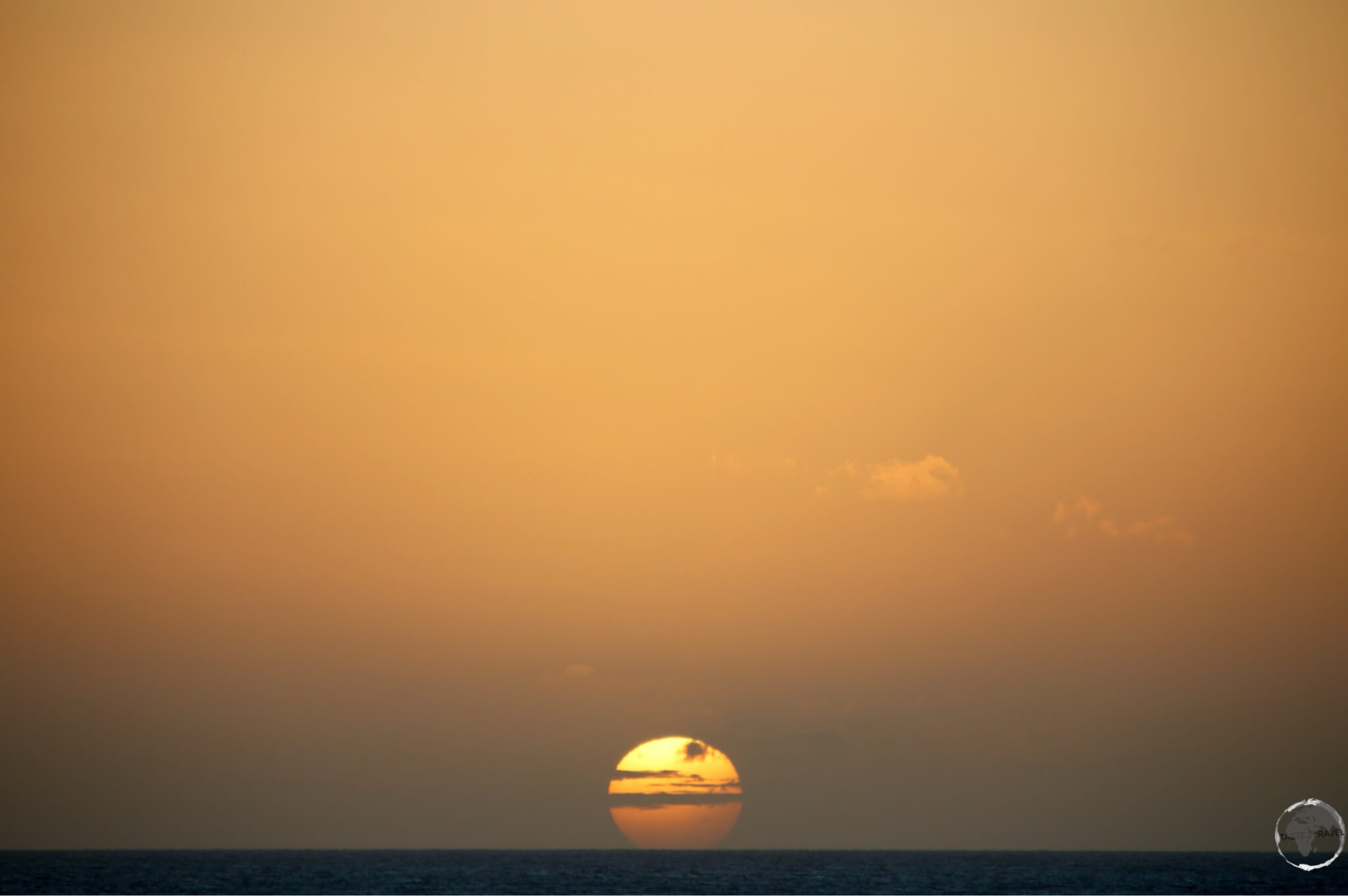
A perfect east coast sunset on Bonaire.
Today tourism is the main industry, this island of 16,500 receives over 100,000 tourists a year. Most come as day-trippers on cruise ships, others come to dive in the Bonaire Marine Park. The largest group of visitors are Dutch and American.

A P&O cruise ship docked at Kralendijk. Bonaire has a total population of 20,000 while some large cruise ships bring 5,000 passengers to the island.
Sightseeing
Kralendijk

Dutch-style buildings in downtown Kralendijk, the capital of Bonaire.
Kralendijk is the capital and largest city (population: 3000) of Bonaire. When a 5000-passenger cruise ship is in port this small town is overwhelmed.
The town developed around Fort Oranje, originally under the English as the settlement of “Playa”. The town was renamed “Kralendijk” by the Dutch colonial rulers in about 1840.

The flag of Bonaire, flying in downtown Kralendijk.
The language spoken in the town is Papiamentu (a creole language indigenous to the Dutch Antilles) but Dutch and English are widely used. In Dutch, Koralendijk (of which the name Kralendijk is a degeneration) means “coral reef” or “coral dike”.

Exploring the south coast of tiny Bonaire, including Willemstoren Lighthouse, in my rental car.
There’s not much going on in this small town. The tourist information office has a walking tour brochure, which covers all of the sites of interest. You could see everything in half a day.
For the best coffee (and ice cream) in town, I recommend Gio’s Gelateria and Caffe, located on the main street – Kaya Grandi.

The Dutch-style town hall in Kralendijk.
Whenever cruise ships are in town there is a market held on the Wilhelmina square. The BBQ sold here makes for a tasty lunch.
Off the coast of Kralendijk lies the uninhabited island of Klein Bonaire, a diving and snorkeling paradise. This small island can be reached by water taxi, or, for divers, by the local dive operators.
Flamingos

Caribbean Flamingos on Lake Gotomeer, Bonaire.
Bonaire is famed for its flamingos. They are drawn to the brackish water of the island’s lagoons, which harbour the shrimp upon which they feed. You can see flamingo populations at the northern and southern ends of the island.
The best viewing is at lake Gotomeer, either at sunrise or sunset.

A Caribbean Flamingo on Lake Gotomeer, Bonaire.
The Pekelmeer Flamingo Sanctuary (southern end of the island) is one of only four areas in the world where flamingos breed. Pekelmeer means “salt lake” in Dutch.
Entry is not allowed in the sanctuary, but the birds can be watched with binoculars from the road.

A Caribbean Flamingo filter-feeding on Lake Gotomeer, Bonaire.
Cactus Vodka
If you are passing through the town of Rincon, you should stop in at the Cadushy distillery.

Cactus vodka from the Cadushy distillery.
A variety of products are made here including the only vodka in the world to be made from a cactus – the Kadushi Cactus.

The Kadushi cactus – the key ingredient for Cadushy vodka.
Bonaire Beaches
Most of the coastline of Bonaire is rocky with a reef running along the entire shoreline, not an island for a beach vacation.
For beach lovers, there are a choice of 22 beaches which offer small strips of sand ranging from soft to larger, coarser grains. The island is primarily a diving destination but a beach holiday is also possible. While on the beach, you should keep an eye out for the curious and not-too-shy Green Iguana which was introduced to the island in colonial times.

Introduced to the island, the Green Iguana is a common sight on Bonaire and is featured in local cuisine.
The focus on the environment on Bonaire ensures pristine waters full of coral, fish and sea life. Bonaire is a “Green Destination”, with the best beaches found on the protected, leeward side of the island (i.e. the west coast).
Diving and Snorkelling

A reef runs along the entire Leeward coast, making Bonaire a diver’s paradise.
Bonaire is known for having some of the best diving in the world! This is the reason most people come to Bonaire…
Bonaire is essentially a coral reef that has been geologically pushed up and out of the sea. This has resulted in the natural fringing reef system you see today, in which the coral formations start at the shoreline. At any point along the coast you can step into the water and start snorkeling or diving. Just beyond the shoreline is a drop-off.
Bonaire markets itself as a divers paradise!

The Bonaire license plate – ‘Divers Paradise’.
The entire coastline of the island was designated a marine sanctuary in 1979 in an effort to preserve and protect the delicate coral reef and the marine life that depends on it.
If you are diving on the island you will be required to purchase the Bonaire Marine Park tag for US$25.00. The tag is valid for one year. SCUBA divers are obliged to display the dive tag on their BCD.
Dive operators can be found along the coast, especially north of Kralendijk.
Salt Mining

The purple briny water of a salt-water pond contrasts against the mounds of white salt at the Cargill Salt Mine.
If you drive south on the island, you will see a series of white hills looming on the horizon. This is the Bonaire salt mine, which is today operated by the American company Cargill.
Salt mining has always been an important industry on the island. Fort Oranje was built by the Dutch in 1639 to defend the harbour, from which the main export was salt. The capital then developed around the fort.

The salt heaps at the Cargill Salt Mine look like snow covered mountains.
During the era of slavery, the Dutch West India Company used African slaves to harvest salt. Salt was one commodity that Bonaire had in endless supply, although it took back breaking slave labour to produce it. In the early days of the industry, the most important use for salt was in the preservation of food, since refrigeration was still centuries away.
At this ‘solar salt mine’ seawater is pumped into evaporation ponds where the water is evaporated through the action of the sun and wind. As the water becomes more briny the level of algae increases and this results in the vivid pink colour. Once all the water has evaporated the remaining salt crystals can be harvested.
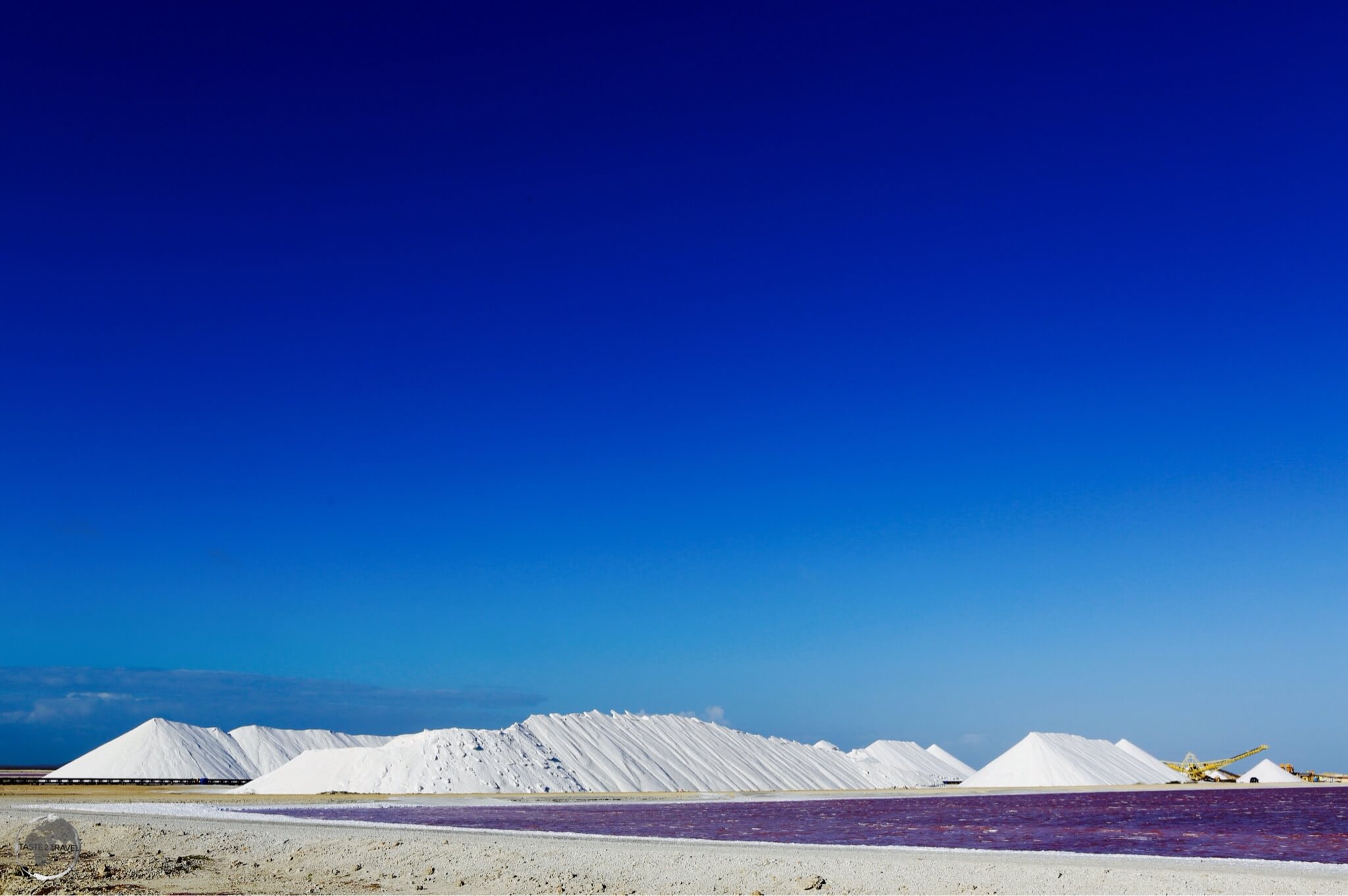
Salt piles at the Cargill salt mine, Bonaire.
Most of the salt produced here is for industrial use, you will not find shops on the island selling cute souvenir packets of locally produced salt for you to use in your cooking.
Accommodation
Bonaire offers a range of accommodation options, especially dive resorts. Many hotels are located on the coast and allow guests direct access to the reef. High season prices apply from December to April. With limited options on the island, it’s best to book ahead using an online agent such as booking.com
I stayed on the coast, just south of the airport, at Bellefonte Oceanfront Hotel. The hotel has a wooden jetty, which provides direct access to the reef.
Eating Out
There are restaurants catering for all budgets scattered around the island, especially in Kralendijk.
The best supermarket on the island is Van Den Tweel, located at 39 Kaya Industria, Kralendijk.
Visa Requirements
Some nationalities require visas for Bonaire – check your visa requirements prior to arrival.
Getting There
By Air
Flights into Bonaire arrive at Flamingo International Airport. Previously, Insel Air provided most connections between its hub at Curaçao airport and Bonaire, however, since its demise, other carriers have taken up the slack. The airport serves as a hub for Divi Divi Air and EZAir.
The following airlines provide services to/ from Flamingo International Airport:
Airport Transport
From the airport, taxis are available. There is no public transport on the island, your best option is to hire a car from the airport.
By Sea
There are no scheduled ferry services connecting Bonaire to any other island. The only way to arrive by sea is by private yacht or cruise ship.
The current Cruise Ship schedule is available here.
Getting Around

My rental car on the west coast of Bonaire.
There is no public transport on the island. You either hire a car, take a taxi or walk. The best option for exploring the island is to hire a car. You should book in advance as demand sometimes outstrips supply. The island can be circumnavigated in just a few hours or in one day at a more relaxed pace.

Visiting the Slave Huts in my rental car.
Follow me on Instagram:
Further Reading
Other travel reports from the Caribbean region include:
Bonaire Travel Guide Bonaire Travel Guide Bonaire Travel Guide Bonaire Travel Guide Bonaire Travel Guide


 to Aruba with Insel Air.")


 are a common sight on arid Aruba.")