Christmas Island Travel Guide
Welcome to the taste2travel Christmas Island Travel Guide!
Date Visited: February 2021
Introduction
An emerald-coloured jewel in the Indian Ocean, Christmas Island is a remote, rugged, unspoilt natural paradise.
A relatively young, volcanic island which rises up 5,000 metres from the floor of the Indian Ocean. An island ringed by razor-sharp, limestone cliffs, the result of ancient geological uplifts, which is topped by a high, jungle-clad plateau.

A view of Flying Fish Cove during rough weather.
Over the course of eons, many unique, endemic creatures have evolved in remote isolation on the island. Christmas Island is a veritable paradise for nature enthusiasts, bird watchers and scuba divers, with an amazing reef system lying just offshore.

The rarest of booby species, Abbott’s booby is only found on Christmas Island.
Just 100’s of metres offshore, underwater cliffs plunge 1000’s of metres into the abyss, to the floor of the Indian ocean.
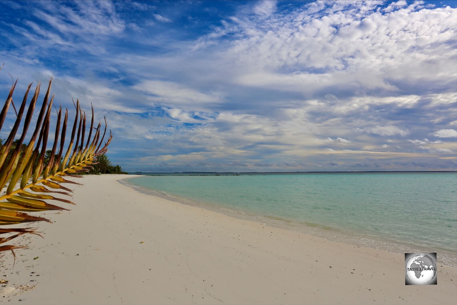
With just a few beaches, which consist of tiny patches of coral-sand and shallow, onshore rocky reefs, Christmas Island isn’t a destination for those looking for a beach holiday.
What is lacks in terms of tropical beaches, it more than compensates for with a dazzling array of natural attractions which make this a compelling destination.

A view of the rugged north coast of Christmas Island.
The island is 19 kilometres (12 mi) in length and 14.5 km (9.0 mi) in breadth, with a total area of 135 square kilometres (52 square miles). Of this, the small population of 1,843 are confined to a small urban settlement, actually called ‘Settlement‘, at the northern tip of the island.
Settlement is divided into three main precincts: Poon Saan, Kampong and Settlement. Each area houses, respectively, the island’s Chinese, Malay and European communities.

An island favourite, a Golden bosun, flying over Flying Fish Cove on Christmas Island.
The main draw of the island, the Christmas Island National Park, covers roughly 63% of the total land area. It’s here you’ll encounter landscapes straight from a Jurassic park movie set and the funkiest of creatures.

The Robber crab (aka Coconut crab) is the largest crustacean in the world, weighing up to 4 kg and measuring 1-metre from leg tip to leg tip
If you dream of exploring a lush, jungle clad volcano which is crawling with millions of Christmas Island red crabs, and the very intimidating-looking Robber crab (aka the Coconut crab), if you dream of observing the rarest of bird species – including Abbott’s booby, which can only be seen on Christmas Island, then you will be rewarded for making the journey to this far-flung corner of the world.

The stars of Christmas Island are the 44 million Christmas Island red crabs.
Location
Flying Fish Cove Shire of Christmas Island, Christmas Island
Christmas Island is located in the Indian Ocean, 1500 km west of the Australian mainland and 2600 km from Perth.
Although it’s an Australian territory, Christmas Island’s nearest neighbour is Indonesia, which lies 350 km to the north. The distance from Christmas Island to Jakarta is about 500 km.
Its second-nearest neighbour is the Cocos (Keeling) Islands (click to read my travel guide), another Australian territory which is located 985 km to the west.
Geologically, Christmas Island is the peak of a volcanic basalt seamount which rises up 5000-metres from the ocean floor. The island is very young at about 60 million years old.

The result of geological uplift, the coastline of Christmas Island features a series of towering limestone cliffs.
Over the course of millions of years, several geological uplifts occurred. At each stage, erosion of the coral reef by the ocean has resulted in cliffs which now form stepped terraces which rise from the sea to the central plateau.
During each uplift, coral reefs built up on the basalt core, creating a limestone cap over the island that remains today. This cap contains rich phosphate deposits which have been mined since 1900 (see the ‘Phosphate Mining‘ section below for more details).
History
Uninhabited, and lying in obscurity for most of its history, Christmas Island was first sighted in 1615 by Richard Rowe, of the Thomas. He laid no claim to the island!
The island was named by Captain William Mynors of the British East India Company, who sailed past it on Christmas day of 1643.
The first Europeans to set foot on the island did so in March of 1688, as part of a landing party travelling with the famed English navigator, William Dampier. It was during his visit to the island that Dampier investigated the sea around the island, however no settlement was established.
The first attempt at exploring the rugged island took place in 1857, when the crew of the Amethyst tried to reach the island’s summit but found the steep cliffs to be impassable.
In 1886, Captain John Maclear of HMS Flying Fish, discovered a safe anchorage in a bay which he named Flying Fish Cove. While on the island, a landing party gathered a small collection of flora and fauna from the island.
A year later, Pelham Aldrich, on board HMS Egeria, visited the island for 10 days, during which time his crew gathered a larger biological and mineralogical collection. The British naturalist, John Murray analysed the mineral specimens and found that they were nearly pure phosphate.
In 1888, the island was annexed by Great Britain and the first settlement was established at Flying Fish Cove by George Clunies-Ross, the owner of Cocos (Keeling) Islands (click to read my Travel Guide), which lie 900 km to the south-west.
Britain granted a 99-year lease to George Clunies-Ross and John Murray, to mine phosphate and harvest timber. Mining commenced in 1899, using indentured labourers from Singapore, Malaysia and China. Eventually, Ross and Murray established the Christmas Island Phosphate Company, Ltd.
In 1900, the island was incorporated into the British colony of the Straits Settlements, which was administered from Singapore.
During WWII, the Japanese, who desired the island’s rich phosphate reserves, occupied the island from the 31st of March 1942 until it was liberated in October of 1945. During this time, much of the population was sent to POW camps in Surabaya (Indonesia).
Christmas Island was managed from Singapore until 1958, when Britain, at Australia’s request, transferred control to Australia. At the time, the decision to hand the island to Australia was hugely unpopular in Singapore and resulted in the Chief Minister, Lim Yew Hock, losing the 1959 General election. This ushered in a new era for Singapore – under the visionary leadership of Lee Kuan Yew!
Today, Christmas Island is a territory of Australia, and is administered as a shire of Western Australia.
People

Artwork on the wall of the Chinese Cultural Heritage Museum in Settlement. Two-thirds of the population of Christmas Island claim Straits-Chinese ancestry.
From the beginning of the 20th century until 1957, Christmas Island was a British colony, administered by Singapore. Many of the Chinese and Malays which inhabit the island today trace their ancestry back to the days of Singaporean administration.
As of the 2016 Australian census, Christmas Island had a population of 1,843 with almost everyone living on the northern tip of the island. At the time of the census, the most common ancestries were Chinese, Malay and Australian, with around two-thirds of the island’s population estimated to have Straits-Chinese ancestry.
Of the three population centres, Settlement is home to many of the Australian ex-pats, Kampong is home to the Malays, while the Chinese dominate the plateau neighbourhood of Poon Saan.
Public Housing

Singaporean HDB-style housing in Kampong.
When I first arrived on the island, one of the things that struck me was how much the public housing looked like HDB housing in Singapore.
There is good reason for this! Almost all of the public housing on the island was built by the Singapore Improvement Trust, the predecessor of the current Housing and Development Board, during Singapore’s period of administration.
Wildlife

A juvenile Abbott’s booby on Christmas Island.
Due to its isolated location, many species found on Christmas Island are endemic and, due to their small number, listed as endangered. Of the bird species, Christmas Island is home to the rarest of the six species of booby birds – Abbott’s booby – which can only be found on Christmas Island.
Likewise, the rarest of frigate birds – the Christmas Island frigatebird, can only be found on Christmas Island.
Birds
Golden bosun

A magical sight, a Golden bosun soaring over Flying Fish Cove.
A sub-species of the White-tailed tropicbird, the Golden bosun is an icon of Christmas Island, appearing on the territorial flag.
While the White-tailed tropicbird can be found on many tropical islands around the world (one is featured on the cover of my Bermuda Travel Guide), the Golden bosun is endemic to Christmas Island.
The best place to view the Golden bosun is from the Territory Day park lookout, the lookout at the Golf course or from the streets of Settlement.
Abbott’s booby

A juvenile Abbott’s booby on Christmas Island.
A highlight of Christmas Island is the chance to observe the rarest of all booby species – Abbott’s booby. Originally discovered by American naturalist, William Louis Abbott, in 1892, Abbott’s booby is the only booby restricted to a single location, although its former distribution covered much of the Indian and Pacific Oceans.
A threatened species, Christmas Island is the only place where the Abbott’s booby nests, with the island supporting an estimated 3,000 breeding pairs.
Red-footed booby

A Red-footed booby on Christmas Island.
No prizes for guessing where this bird gets its name from!
With its conspicuous red feet and pale-blue bill, the noisy Red-footed booby is easily spotted as it perches in trees around the island, with many seeming to enjoy perching next to the roadside.

A curious Red-footed booby on Christmas Island.
A good place to see the Red-footed booby is along the road which leads to Ethel and Lily beach, where you’ll hear them before you see them!
Unlike Brown boobies, who are ground dwellers, the Red-footed booby prefers to live and nest in trees. Christmas Island is home to an estimated 12,000 breeding pairs.
Brown booby

A not-so-shy juvenile Brown booby on the boardwalk at the blow holes.
I first photographed the Brown booby on the Cayman Islands while island hopping through the Caribbean. I’ve since had the opportunity to photograph this adorable booby on many other tropical islands.
Unlike the Abbott’s and Red-footed booby, the Brown booby prefers to nest on the ground and is easily spotted around the blow holes on the remote south coast.
During my visit, one juvenile Brown booby had decided to take up residence on the blow holes boardwalk – right next to one of the sitting benches! Typical behaviour for this gregarious species of booby.
Great Frigatebird

A male Great frigatebird, with a deflated red gular sac, on Christmas Island.
Christmas Island is home to the widely distributed Great frigatebird and the endemic Christmas Island frigatebird.
The male Great frigatebird is easily recognisable thanks to its striking red gular sac which it uses to dramatic effect during mating rituals when it forces air into it, inflating it like a huge red balloon.

A Great frigatebird on Christmas Island, chasing a Golden bosun for its catch.
A peculiar feeding habit of the frigatebird is that it doesn’t dive for its own food, but rather chases other seabirds, forcing them to regurgitate their catch which the frigatebird then steals. A real pirate of the seas!

A male Great frigatebird, with an inflated red gular sac, flying over Christmas Island.
On Christmas Island, the frigatebird can be seen chasing the Golden bosun and various booby birds, all of whom are expert fish divers.

Frigatebirds flying over Flying fish Cove on Christmas Island.
Christmas Island Frigatebird

A juvenile Christmas Island Frigatebird on Christmas Island.
An endangered species, the Christmas Island Frigatebird can be seen flying over Settlement and Flying Fish Cove. The world’s rarest frigatebird, there are an estimated 1,200 breeding pairs on Christmas Island.
Christmas Island Imperial Pigeon

A Christmas Island Imperial Pigeon feeding off the fruit of a papaya tree.
Endemic to Christmas Island, the Christmas Island Imperial Pigeon is one of only two fruit-eating animals on the island, the other being the Christmas Island flying fox.
With a breeding population estimated to be around 5,000 – this beautiful pigeon, which features purple and green plumage, inhabits the plateau region of the island, feeding in the forest canopy or anywhere else fruit trees can be found.

A Christmas Island Imperial Pigeon, in the Christmas Island National Park.
Although often heard, with their distinct cooing sound ringing out over island neighbourhoods, the Christmas Island Imperial Pigeon is often hard to find. At about twice the size of a regular domestic pigeon, this imperial pigeon spends most of its time hidden away in the high forest canopy.
The favoured habitat for the Christmas Island Imperial Pigeon is the evergreen inland plateau, and it was here, after much searching, I happened upon a large flock of them feeding on the fruit of several isolated papaya trees.
Christmas Island Thrush

A sub-species of thrush, the Christmas Island Thrush is endemic to Christmas Island.
Another endemic species, the Christmas Island Thrush is easily spotted on Christmas Island, where it feeds off the ground, mainly eating insects, seeds and earthworms.
While they are plentiful on the island, due to its limited area of distribution, the Christmas Island Thrush is listed as endangered.
Feral Chickens

Feral chickens surround my rental car on Christmas Island.
One other bird which deserves a special mention is the feral chicken. Introduced to islands around the world by early sailors, Christmas Island is home to a countless number of feral chickens.
While they can be observed all over the island, scratching around in the rich volcanic soil, one place where they seem to be especially prolific is in the cemetery section of the island, just north of Settlement.
Crabs
Christmas Island Red Crab
The star of the show! The famous and iconic, Christmas Island red crab, is endemic to the island, and rules over it, with a population of 44 million occupying most parts of the island.

The Christmas Island red crab is a very common sight on Christmas Island where they number around 44 million.
It’s hard to walk anywhere without looking out for these red critters who always seem to be scurrying around your feet. Driving on the island also requires attention as you need to keep an eye out for the numerous crabs which seem to love dawdling across the roads.

A road sign in Settlement indicates road closures during the Red Crab migration season.
For most of the year, red crabs can be found within Christmas Islands’ forests. However, at the beginning of each wet season (usually October/November), the crabs migrate en masse to the coast where they breed by laying their eggs in the ocean. During this time some of the roads on the island are closed to traffic.

A unique piece of infrastructure! The Christmas Island red crab bridge allows crabs to cross this road safely.
This migration was made famous by Sir David Attenborough who featured it in one of his epic documentaries. He described it as one of the “ten greatest natural wonders on Earth”.

My rental car, waiting for a Christmas Island red crab to cross the road.
Due to the huge numbers of red crabs on the island, some unique infrastructure has been developed by Parks Australia to help protect them.
This includes a red crab bridge, which is located on Murray road, just beyond the island’s only high school. The road is used by phosphate mining trucks which necessitated a higher bridge, with a clearance of 5.5 metres. Quite a climb for the little crabs!

Metal barriers line the roads inside Christmas Island National Park, preventing red crabs from meandering onto the road.
Inside the National Park (which covers most of the island), Parks Australia have constructed small, metal barriers which run alongside the road, preventing the crabs from entering the road.
How are they to cross the road?

Cattle grids on an island with no cows! Grids on Christmas Island allow for red crabs to pass safely under the road.
On an island where there are no cows, it’s strange to be passing over so many cattle grids. The grids have been installed to allow the crabs to pass safely under the road, with the metal barriers herding the crabs into tunnels which pass under the grids.
On Christmas Island, it’s all about the crabs and rightly so!

Christmas Island red crabs, feasting on a recently fallen mango.
While the Christmas Island red crabs have no predators, they are under attack from the yellow crazy ant which was accidentally introduced to the island from South-east Asia. The ant is believed to have killed 10–15 million red crabs in the last years.
Christmas Island Blue Crab

A Christmas Island blue crab, hiding in his burrow near Hughs Dale waterfall.
One of my favourite creatures on Christmas Island is the Christmas Island blue crab. Endemic to the island, and found in only one small area, this shy and elusive, sky-blue, crab can be found in the fresh water stream which flows down from Hughs Dale waterfall.
Reliant on fresh water, and living off a diet of fallen leaves and fruits, the blue crab builds its burrow alongside the stream and can often be found submerged in the stream itself, where it keeps cool during the heat of the day.
Coconut Crab (aka Robber Crab)

A robber crab on an asphalt road on Christmas Island. You always give way to these giants when they’re crossing the road.
The truly massive, Coconut crab, which is known on Christmas Island as the Robber crab, is the world’s biggest land crustacean. Adult crabs can weigh up to 4 kg and measure 1 metre across, from each tip to tip of the leg.
The Robber crab is capable of climbing the trunk of the coconut tree to select a coconut and cut it free using its pinchers. Its claws are so powerful it can remove the husk from the coconuts. The Robber crab uses coconut husk as bedding in its burrow.
The name Robber crab has existed for centuries and refers its habit of carrying off any foreign items it comes across. It especially likes shiny objects!
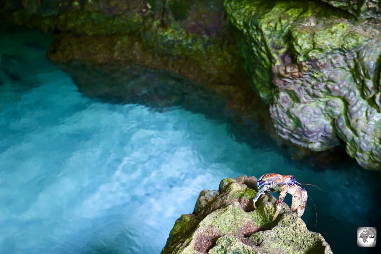
A Robber crab climbing out of the Blue grotto on the north coast of Christmas Island.
My first encounter with a Robber crab was while I was photographing, the much smaller, Christmas Island Red crabs inside the Blue grotto on the island’s north coast.
Out of the corner of my eye, climbing slowly up a rock face, I noticed something truly bizarre – a huge, colossal, and terrifying looking, creature, the likes of which I had never seen before. This was something that could have played a starring role in a science fiction film.
It was my first sighting of a Robber crab and, during my 8 days on Christmas Island, I had the pleasure of seeing many more of these gentle giants.
Often while walking along lonely jungle trails on Christmas Island, Robber crabs can be seen lurking menacingly in the bushes. They are however completely harmless!
I once saw a local expat stop his car and pick a Robber crab up, holding it carefully by its large abdomen, removing it from the road, placing it out of harm’s way in some nearby bushes.

A road sign on Christmas Island, where the Robber crab is protected.
Christmas Island has the world’s largest and best protected population of Robber crabs, with road signs on the island reminding motorists to drive around them.
While the crabs were once distributed on islands throughout the Indian and Pacific Oceans, hunting by humans has resulted in the crab becoming extinct in certain locations. Where they do exist, they are often much smaller since adults are killed for their meat.
Thanks to their protected status, the crabs are thriving on Christmas Island and often grow to their full (enormous) adult size.

A robber crab crossing the road on Christmas Island.
The crabs on Christmas Island can be found on the highest points of the island and live in burrows which they line with fibres from coconut husks which is used as bedding.
Robber crabs can be seen on most parts of the island, where they forage for food on the floor of the forest. They are most easily spotted while crossing the road and can even be seen climbing trees. The crabs are considered one of the most terrestrial-adapted of crustaceans and will actually drown if they spend too long in sea water.
Despite their intimidating looks, they are not threatening and are very gentle and, at times, comical.
Reptiles

The tiny, Blue-tailed skink, is endemic to Christmas Island.
Blue-tailed skink
Endemic to Christmas Island, and once found all over the island, this tiny skink had almost become extinct as a result of introduced predators, who ravaged the population.
Thanks to a captive breeding program, which is being conducted by Parks Australia, at their Pink House Research Station, these skinks are making a slow recovery.
You can join one of their lizard feeding tours by registering through the Christmas Island Visitor Centre.
One place where the lizards have been successfully re-introduced back into the wild is on Pulu Blan, on the Cocos (Keeling) Islands. You can visit Pulu Blan as part of a Motorised Canoe tour, which are conducted by Ash and Kylie of Cocos Islands Adventure Tours.
Flag

The flag of Christmas Island.
The flag of Christmas Island, which was officially adopted in 2002, consists of a green and blue background, split diagonally, with the blue representing the sea while the green represents the land.
The Southern Cross constellation appears in the bottom left corner, while the top right corner features a Golden bosun bird in flight. At the centre, a golden disc features a map of the island in green.
The flag was originally designed in 1986, following a competition which offered a prize of A$100! The design was created by Tony Couch of Sydney, who had formerly been resident on the island.
Currency

The Australian dollar is the official currency of Christmas Island.
The official currency of Christmas Island is the Australian dollar (A$), which trades under the international currency code of AUD.
Having the distinction of being the world’s first polymer currency, the dollar is issued in bank notes of $5, $10, $20, $50 and $100 and is divided into 100 cents (c), with coins being issued in denominations of 5c, 10c, 20c and 50c, $1 and $2.
All bank notes are printing in Melbourne by Note Printing Australia (a division of the Reserve Bank of Australia), who also print polymer bank notes for Central banks around the globe.
Like mainland Australia, most transactions on Christmas Island are cashless with credit cards being widely accepted.
To check the current exchange rate between the Australian dollar and the US dollar, click here.
Banking Services

The Westpac bank branch on Christmas Island.
Westpac are the only bank to maintain a branch on Christmas Island, although there is no ATM available. The adjacent post office acts as an agent for all other Australian banks and is able to provide cash advances.
There are no ATMs on Christmas Island.
Costs
With the exception of duty-free alcohol, Christmas Island isn’t a cheap destination with everything imported from Australia. Air freight charges add an additional A$9 per kilo to everything with a lettuce at the supermarket fetching A$18!
Like neighbouring Cocos (Keeling) Islands, the two major expenses are flights and accommodation, with the latter being slightly cheaper on Christmas Island.
Some sample costs:
- Return Virgin Australia airfare to Christmas Island from Perth: $A1,100 (US$842)
- Room (per night) at CI Apartments: A$160 (US$123)
- Cappuccino/ Cafè latte at Smash Cafe: $A5 (US$3.80)
- Bottle of beer at the Golden Bosun tavern: $A6 (US$4.60)
- Eggs on Toast at Smash Cafe: $A17 (US$13)
- Chinese dinner at Lucky Ho restaurant: $A30 (US$23)
- Car Rental with Kiat Car Rental (per day): $A65 (US$50)
- 1 litre of petrol: $A2.28 (US$1.75)
Philately

The stamps of Christmas Island feature the rich fauna and flora of the island.
Christmas Island issues its own stamps which are produced by Australia Post. Stamps feature the fauna and flora of the island and also include subjects relevant to the local (mainly Chinese) community, with Chinese New Year stamps being a popular issue.

Christmas Island stamps featuring views from the National Park.
Like neighbouring Cocos (Keeling) Islands, the number of stamp issues produced each year has been dramatically reduced. Stamps can be purchased from the one post office on Christmas Island or online from the Australia Post website.

The Christmas Island post office.
Phosphate Mining

A view of the (beige-coloured) Phosphate storage sheds and the cantilever on Christmas Island.
Introduction
Occupational Health & Safety (OH&S) is taken very seriously in Australia, so it’s not surprising that the phosphate mines on Christmas Island are strictly off-limits to visitors.
What can be seen are the conveyors, which transport the phosphate down the cliff face from the central plateau, to the port, and the cantilever which is used to load the phosphate onto export ships.
Like Christmas Island, phosphate mining has also been an important export earner for the Pacific island nation of Nauru, an island which is a lot more casual about mine access, with mines operating openly by the side of the road on Topside (Nauru’s phosphate-rich plateau).
Some of the text in this section has been extracted from my Nauru Travel Guide which includes a more detailed section on phosphate mining, including photos of the mining process.
Apart from phosphate, the two islands also share something else in common – they both host an Australian Refugee Detention Centre.
What is Phosphate?

Blackened limestone rocks, such as these on the plateau at Christmas Island, are the tell-tale sign of a former Phosphate mine.
Phosphorite, or phosphate rock, is a sedimentary rock that contains high amounts of phosphate minerals. The two main sources for phosphate are guano, formed from bird droppings, and rocks containing concentrations of the calcium phosphate mineral.
Christmas Island’s phosphate deposits are the result of thousands of years of bird droppings. Guano is a highly effective fertiliser due to its exceptionally high content of all three key fertiliser ingredients – nitrogen, phosphate and potassium.
Following the discovery of processes which allow for the creation of synthetic fertilisers, the demand for naturally occurring phosphates has declined.
How is Phosphate Used?
Phosphate is one of three key ingredients which are used in fertilisers. Normally, fertilisers are labelled with an ‘N-P-K’ rating, with phosphate being the ‘P’ component; nitrogen being the ‘N’ and potassium being the ‘K’.
An NPK value of ’10-5-5′ means that the fertiliser contains 10% nitrogen, 5% phosphate and 5% potassium.
Phosphate is a key component for plant food and plants are key for human survival.
Phosphate on Christmas Island
Phosphate was first discovered on Christmas Island by a British expedition which arrived on the island in 1887. The purpose of the expedition was to collect plant and animal specimens. It was during the expedition that rich reserves of phosphate were discovered. This led the British to annex Christmas Island in 1888, to claim its valuable phosphate deposits.
The British offered George Clunies Ross, the owner of the neighbouring Cocos (Keeling) Islands and John Murray a joint 99-year lease in return for a small royalty. They began exporting phosphate in 1895, establishing the Christmas Island Phosphate Company in 1897. The first major shipment of phosphate was exported in 1900.
The proceeds from phosphate mining proved to be much more lucrative for the Clunies-Ross family than the proceeds from their Copra operation on the Cocos (Keeling) Islands.
As there was no Indigenous population on Christmas Island, a workforce had to be imported from Europe, Singapore, China and Malaysia. Working conditions in the early days were appalling with an estimated 500 Chinese workers dying in the first 5 years due to vitamin deficiencies.
During WWII, the island came under attack from the Japanese who wanted to disrupt shipments of phosphate. In 1948, the Australian and New Zealand Governments purchased the Christmas Island Phosphate Company which they worked in partnership with the British Phosphate Commissioners.
Due to dwindling reserves, a decision was made to close the mine in 1987. With the island’s main employer shutdown, locals were not happy.
In 1990 the mine was purchased by local union workers (many of whom used their own savings to fund a feasibility study) and reopened as Christmas Island Phosphates.
Since 1990, Phosphate Resources Limited (now a part of CI Resources – ASX: CII) has operated the mine, which has since been granted a license to continue mining until 2034. The main market for CI phosphate is South-East Asia.
Sightseeing
Sightseeing on Christmas Island is all about the incredible fauna and flora, which can be observed on every inch of the island, but especially inside the boundaries of the Christmas Island National Park which covers two-thirds of the island. Within the small populated area of the island are a few man-made sights of interest.
This sightseeing section starts with sights around Settlement, then radiates out to cover each section of the island.
Flying Fish Cove

A view of Flying Fish Cove in the foreground with The Settlement in the background, the main population centre on Christmas Island.
The first settlement on Christmas Island was established by George Clunies-Ross, the owner of the Cocos (Keeling) Islands at Flying Fish Cove in 1898.

Flying Fish Cove is the one beach on Christmas Island which allows swimming – but only on calm days.
While the coastline of Christmas Island is almost entirely fortified by towering, razor-sharp, limestone cliffs, Flying Fish Cove offers the only break in this line of defence, making it the only reasonable landing site on the island.

A view of Flying Fish Cove from the Territory Day park lookout.
Flying Fish Cove is also home to one of the few beaches on the island, which is very exposed and only safe for swimming in calm weather.
Christmas Island Port

A container ship being unloaded at sea at Christmas Island port.
Flying Fish Cove is one of the main centres of activity on Christmas Island, being home to the only port, post office, bank and the administrative buildings for the IOT (Indian Ocean Territories of Christmas Island and Cocos (Keeling) Islands).
Port facilities are a real issue for the island at the moment. With almost everything being imported on one container ship, it’s critical that the ship is able to arrive and unload on schedule.
At the time of my visit, in March of 2020, the ship that was due in December of 2019 still had not been able to land any containers due to rough seas.
The following day, the ship arrived and was able to offload 15 containers, one at a time, onto a barge, which then transferred them to the shore where a crane lifted them onto the dock.

Shipping containers at Christmas Island are offloaded onto barges and then transported to shore.
Of the 100 containers scheduled to be ‘landed’, only 15 made it ashore before a cyclone warning and increasingly rough seas meant the ship had to return to the Australian mainland. It would be seven weeks before the ship would return to continue offloading the cargo which was due in December. This included the islands’ supply of aviation fuel, which had just run out!
Locals told me that they had Christmas presents waiting to be offloaded in one of the containers. Another container, which had been packed with fresh produce in December, had to be dumped since its contents were completely spoilt. Meanwhile, the supermarkets on the island have bare shelves and desperately wait for containers to be landed.

Located in Kampong, the Masjid At-Taqwa is the one mosque on Christmas Island.
Lining the cove is the small village of Kampong which is home to a predominately Malaysian (Muslim) population who live in Singapore-built HDB-style housing.
It is here that the one mosque on the island, the Masjid At-Taqwa, and two Malaysian restaurants, are located.
Tai Jin House

Tai Jin house is the former Administrator’s House, a heritage-listed former official residence and now the Christmas Island museum.
Located atop a sea cliff beyond Flying Fish Cove, the historic Tai Jin house once served as the residence of the British Administrator of Christmas Island.

A museum display at Tai Jin house.
With the current administrator living in Settlement, Tai Jin house is today used as a function centre for official ceremonies and houses the island’s only museum on its 1st floor.
The museum tells the story of the development of Christmas Island and is the best place to gain an understanding of the history of the island from its early discovery and European settlement in 1898 to the present.
WWII Gun Emplacement

The WWII gun emplacement on Christmas Island.
The island’s rich phosphate deposits and strategic location made it a target for the Japanese during World War II. In order to defend the island, a gun emplacement was established on a cliff, overlooking the Indian Ocean, a short walk from Tai Jin House.
SIEV 221 Memorial

The SIEV 221 memorial on Christmas Island.
Located on the grounds of Tai Jin house is a memorial which commemorates those who lost their lives in the sinking of the asylum seeker boat, known as SIEV 221.
On the 15th of December 2010, a boat carrying around 90 asylum seekers, mostly from Iraq and Iran, sank off the coast of Christmas Island, killing 48 people while 42 survivors were rescued.
This tragic incident took place in front of the residents of Settlement, with the flimsy, wooden, Indonesian boat being smashed up against the limestone cliffs at Rocky Point. Settlement sits atop these sea cliffs with access to the sea near impossible, however locals were able to throw life jackets and other floatation devices into the water.
Shocking video images of the disaster were broadcast around the world. The boat was later named SIEV-221 by the Australian authorities who use SIEV as an operational term meaning “Suspected Irregular Entry Vessel“.
The memorial plaque reads:
“We will reflect on this day with sadness. The loss of each person`s life diminishes our own because we are part of humankind.
As you read this please remember all asylum seekers who have attempted this treacherous journey.”
Settlement

The coast at Settlement is lined with razor-sharp limestone cliffs.
The main town centre on Christmas Island, Settlement is home to a supermarket, the one pub on the island, the one police station, a few accommodation options, a couple of dive shops, the Chinese Cultural centre and a Chinese temple.
It’s also home to Wild Papaya which offers the one good shopping opportunity on the island (see the ‘Shopping‘ section below for more details).

A whale shark, frigatebirds, a booby and more feature on a newly installed, community-made, tile mosaic in the park in Settlement.
Chinese Cultural and Heritage Museum

Displays at the Chinese Cultural and Heritage Museum in Settlement, on Christmas Island.
Christmas Island has a long history of settlement by the Chinese, who first arrived on the island as indentured labourers to work in the phosphate mines.
Located in a small house, opposite the CLA restaurant in Settlement, the one-room Chinese Cultural and Heritage Museum includes displays which highlight the cultural heritage of the Chinese who have been instrumental in the development of Christmas Island.
Access during the day is free, with the museum normally unattended.
Tai Pak Kong Temple

Tai Pak Kong Temple serves the Chinese community at Settlement on Christmas Island.
With two-thirds of the population of Christmas Island being Straits-Chinese, there are a number of Buddhist temples spread around the island. Located in the heart of Settlement, Tai Pak Kong Temple serves the local Chinese population.
Located adjacent to the temple is Wild Papaya, a great place to shop for local arts and crafts.
European Cemetery

The original European cemetery on Christmas Island.
The first European cemetery on Christmas Island is located on an overgrown hill behind the Westpac bank in Settlement.
The last person to be buried here was a young sailor whose dead body was recovered from a Royal Australian Navy life raft which drifted ashore on the 6th of February 1942.
It is believed the sailor was from the HMAS Sydney which was sunk off the coast of Geraldton, Western Australia in November of 1941, after a battle with a German cruiser. The unknown body was buried in the cemetery in an unmarked grave.
Chinese Cemetery

A gravestone at the Chinese cemetery on Christmas Island.
Located north of Settlement, along Gaze road, is a large Chinese cemetery.
Muslim Cemetery

Gravestones at the Muslim cemetery on Christmas Island.
Directly across the road from the Chinese cemetery is a Muslim cemetery which seems to be a favourite locale for a large number of feral chickens.
Christmas Island National Park

The Christmas Island National Park occupies most of Christmas Island.
Managed by Parks Australia, the Christmas Island National park protects 2/3 of the land area of Christmas Island, ensuring the numerous endemic creatures, which call the island home, are fully protected and that the pristine jungles remain untouched.
As part of their management, the enthusiastic team of volunteers at Parks Australia offer two free weekly sessions for visitors, the feeding of orphan booby chicks at the headquarters of Parks Australia and a lizard feeding session at the Pink House.
National Park Headquarters – Bird Feeding

An Abbott’s booby chick being fed at the National Park bird orphanage.
If you’re a keen ornithophile, you should not miss the weekly bird feeding session which is conducted by volunteers at the National Park headquarters, each Wednesday at 3 pm.
During the session, volunteers feed orphaned Booby chicks. During my visit, all three species were present – Abbott’s, Brown and Red-footed.
This is a free activity, but bookings must be made in advance at the Christmas Island Visitors Centre.
Pink House – Lizard Feeding

The Lizard Lounge at the Pink House is home to the endemic Blue-tailed skink and Lister’s gecko.
Hidden away in the middle of the jungle is the Pink House Research Station which is home to a breeding program, run by Parks Australia, whose aim is to rehabilitate the dwindling populations of two endemic lizards, the blue tail skink and Lister’s gecko. Both species have been decimated, following the accidental introduction to the island of the Yellow crazy ant from South-East Asia.
The program has been a success with the blue tail skink being introduced into the wild on tiny Pulu Blan on the Cocos (Keeling) Islands.
If you wish to view the lizards, you can join the weekly feeding session which is conducted every Wednesday at 1 pm.
This is a free activity, but bookings must be made in advance at the Christmas Island Visitors Centre.
North-east Coast
The Blue Grotto

The Blue grotto is located on the North coast of Christmas Island.
Located at the end of a short walking trail on the north-east coast, the Blue Grotto is a magical place where large, dripping limestone rocks hang decoratively over an azure-blue pool of half-fresh, half-salt crystalline water.
Lily Beach

A view of Lily beach on Christmas Island.
While most of the 80 kilometres (50 miles) of shoreline on Christmas Island is inaccessible, there are a few places where a break in the limestone cliffs provides access to the sea. Swimming however is hardly ideal with most beaches full of rocky, sharp limestone boulders.
One beach popular with locals is tiny Lily beach, which allows for a little paddling, in a small protected pool, during high tide. Beyond the rocks, the deeper water is normally too rough for swimming with currents waiting to carry you away.

A boardwalk connects Lily beach to Ethel beach.
A boardwalk from Lily beach leads around the headland to neighbouring Ethel beach.
Ethel Beach

A view of the coral-sand Ethel beach, which is submerged at high tide.
Located on the north-east coast, a short distance from Lily beach, Ethel beach offers a narrow stretch of coarse coral-sand which is fully submerged at high tide.
South Coast
Blowholes

A view of the many blowholes, which line the remote south coast of Christmas Island.
Located on the remote, isolated, south coast, at the end of a rough gravel track, are the magnificent blowholes.
Towards the end of the track, a sign recommends that anyone not driving a 4WD, not to proceed beyond the hilltop carpark. From the carpark, a steep track descends through a dark, overgrown, pre-historic, jungle which is home to enormous Tahitian chestnut trees, whose many buttress roots are alive with thousands of scurrying red crabs. This is the stuff of Indiana Jones!
At the bottom of the decent, the jungle opens up to a thin strip of pandanus trees which protects the jungle vegetation from the harsh sea elements.
Beyond this thin line of defence, the coast is lined with the sharpest of limestone rocks, which plunge into the sea. The entire coastline is comprised of an unbroken line of towering, razor-like, limestone sea cliffs.

An excellent boardwalk at the blowholes allows visitors to pass over the razor-sharp limestone foreshore.
An elevated boardwalk allows visitors to pass over this, otherwise impassable, landscape where numerous blowholes can be viewed. The best time to visit is during high tide, when giant waves are forced through holes in the underlying rock, making a tremendous noise as the water exits, shooting skywards.

A Brown booby on the boardwalk at the blowholes.
The area around the blowholes is a popular nesting site for Brown boobies. During my visit, one, very social, Brown booby had taken up residence on the boardwalk, sitting right next to one of the sitting benches.
South Point

The Soon Tien Kong Temple at South Point is the only active reminder of the once thriving community which once lived here.
Today, there is nothing much at lonely South Point, which lies at the end of a long, gravel road, 20-kilometres (12.5-miles) from Settlement.
While today it is an empty, overgrown corner of the island, in former times it was the Island’s most significant residential area, home to a thriving community from 1914 to 1974.
The area around South Point was the main source of phosphate for decades, with a rail line connecting the community to the rest of the island on the north coast.

The abandoned railway station at South Point.
When the South Point ore deposits were approaching exhaustion, the upper Poon Saan residential area was built to house people who were relocated from South Point. Once relocation was completed, the South Point residential area was almost totally cleared so that the ground beneath could be mined.
Demolition of South Point was completed in 1977. Due to the demolition, little remains if this once thriving community. What can be seen today are the remains of the South Point railway station and the (still active) Soon Tien Kong Buddhist temple.
West Coast
Hughs Dale Waterfall

A view of Hughs Dale waterfall on Christmas Island.
The Dales area is the highlight of the uninhabited West coast. A series of forested ravines which plunge towards the coast, the dales are the one place on Christmas Island where fresh water flows all year round.

The boardwalk to Hughs Dale waterfall on Christmas Island.
These rain-forested ravines are home to towering Tahitian chestnut trees and the adorable, but very shy, Christmas Island blue crabs, who are dependent on a constant supply of fresh-water.
A Christmas Island blue crab, hiding in his burrow near Hughs Dale waterfall.
The Hughs Dale track is a raised boardwalk that leads to the Hughs Dale waterfall which flows all year round. Beyond the Hughs Dale track, a rough, unmarked track leads 900 metres further to Andersons Dale.

The buttress roots of a giant Tahitian chestnut tree at Hughs Dale waterfall.
Scuba Diving
Scuba diving on Christmas Island is offered by two dive operators who maintain dive shops in The Settlement:
Christmas Island Wet’n’Dry Adventures
Email: Hama@divingchristmas.com
Extra Divers
Email: christmasisland@extradivers.org
Shopping

The best shopping on Christmas Island is at the Wild Papaya boutique in The Settlement.
Wild Papaya
Whenever locals wish to do serious shopping, they fly to Perth! There are few shopping opportunities on Christmas Island, but one place which shouldn’t be missed is Wild Papaya which is located in The Settlement.

Wild Papaya sells a range of locally produced crafts, artworks and photography.
Located next to the Tai Pak Kong temple, this inviting Aladdin’s cave is full of local gifts, crafts, artwork, souvenir tea-towels, photography and so much more.
If you wish to purchase a souvenir of Christmas Island, this is the place to do it!
Accommodation

My wonderful accommodation on Christmas Island – the very new CI Apartments in Poon Saan.
Christmas Island offers a good range of accommodation options, all of which can be viewed and booked online through the Accommodation page of the Christmas Island Visitor Centre website.
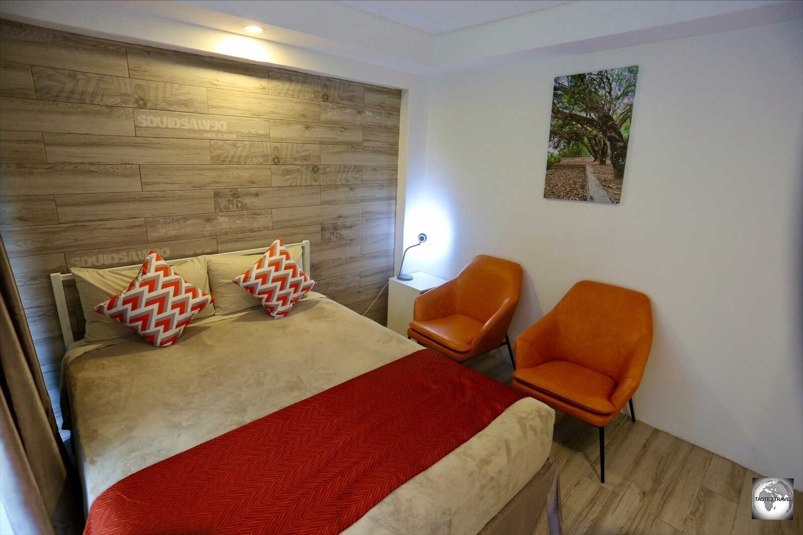
My room at CI Apartments in Poon Saan.
Whether you choose to stay in a guest house, apartment, lodge or private home, almost all accommodation options are located on the north coast in Settlement and Kampong and in the plateau neighbourhood of Poon Saan.

CI Apartments provided a comfortable base for my week-long stay on Christmas Island.
While on the island, I chose to stay at the excellent CI Apartments which is a newly built complex, offering apartments in different configurations.
The apartments are located in the, mainly Chinese, neighbourhood of Poon Saan, next door to a supermarket, the excellent Smash cafe, a fish and chip shop and a short walk from the Lucky Ho Chinese restaurant.

My bathroom at CI Apartments.
CI Apartments are owned by the wonderful Jenny, an industrious local of Chinese descent, who also operates the Kiat Car rental agency.
Eating Out

Menu prices on Christmas Island, such as these at the Golden Bosun pub, can be shocking!
Christmas Island is no paradise for gourmands, with the few restaurants keeping irregular hours and offering a selection of mediocre, over-priced food. To be fair – air freight adds $9 per kilo to all imported items, which is pretty much everything.
Finding food can be a challenge during the day with many of the morning options closed by 11 am, while dinner options open around 6 pm. Places which are open one day are shut the next.

The very useful, Christmas Island dining guide, which is issued by the Christmas Island Visitor Centre
Recognising how confusing this can be for the uninitiated, the Christmas Island Visitors centre issues a handy Dining Guide to all tourists arriving at the airport. This single page leaflet is laid out like a calendar, listing which restaurants are open on a particular day for breakfast, lunch and dinner. It is indispensable!
Cafés

The interior of Smash Espresso bar, the most popular café on Christmas Island.
Smash Espresso Bar

The take-away window at Smash Espresso bar.
Located in the small Poon Saan shopping centre, the Smash Espresso Bar is a very popular café, drawing in the locals and most tourists on the island. Offering the best coffee on the island, the cafe features a typically Australian breakfast menu, featuring bacon and egg wraps, eggs benedict and much more.
Owned by a friendly Thai/ Australian husband and wife team, the cafe is open every morning with most items reasonably priced.
A big challenge for any food business on Christmas Island is the supply of imported items, which are air freighted in once every two weeks.
Fresh milk is not available on the island, with cartons of UHT milk being used instead. During my stay, the cafe was close to running out of milk supplies which is a real problem when there’s nowhere else to go to buy more supplies.
Halal Café

The menu at Halal café features many Malaysian favourites.
I love nothing more than a good Malaysian breakfast, so I was pleasantly surprised to find the Halal café, a Malaysian cafe in the Kampong neighbourhood, where I could enjoy a typical Malaysian mamak breakfast.

The perfect Malaysian breakfast at Halal café – Teh Tarek and Roti Telur.
This tiny café, which is tucked in behind the mosque in the Kampong neighbourhood, offers a very reasonably priced menu which features roti canai and roti telur (my favourite roti) which is best enjoyed with a freshly made Teh Tarek (pulled tea).
The friendly and enthusiastic staff provide a wonderful level of service with the cafe closing at 11:30 am.
Idah Kitchen
Located across the laneway from the mosque, and around the corner from Halal café, Idah Kitchen also offer typical Malaysian food which is served on their balcony, overlooking Flying Fish Cove.
Like most eating establishments on Christmas Island, the opening hours are tricky with the restaurant closed on Tuesday, Wednesday and Friday and open all other days from 6:30 am to 12:30 pm.
CI Bakery Cafe
Located next to the CI Visitors centre, the low-key CI Bakery Cafe is open most mornings, and some evenings, serving a selection of Chinese, Malay and Western-style food.
From Fried Kuay Teow to Kung Pow chicken, Nasi Lemak to Chicken Carbonara pasta, this bakery offers much more than fresh bread. They also sell a range of homemade cookies.
Poon Saan Coffee Shop
Located next to the Smash Espresso Bar in the Poon Saan shopping centre, the Poon Saan Coffee Shop serves a selection of Chinese meals which are especially popular with the local Chinese community.
This coffee shop is closed on Saturday but open every other day from 6 am to 11 am.
Restaurants
Golden Bosun Tavern & Restaurant

Salmon with chips and salad costs A$42 at the Golden Bosun pub on Christmas Island.
The Golden Bosun Tavern & Restaurant is the one place on the island which serves pub meals and alcohol 6 nights a week, closing only on Monday.
It’s also the only bar on the island and is, without doubt, the most popular place to socialise. If you wish to meet local ex-pats, this is the place to be!
While the meals are good, the prices are very high with a garden salad costing A$28! This is only a reflection of the cost of imported produce, where a lettuce costs A$18 at the supermarket.
Le CLA Café and Restaurant

The entrance of Le CLA Café and Restaurant in Settlement.
The Chinese Literary Association (CLA) operate the very popular Le CLA Café and Restaurant which is located next to the Christmas Island Visitor Centre in Settlement.

Artwork on the wall of the CLA restaurant in The Settlement.
Offering tasty Chinese food, CLA also serves as a de-facto community centre for the close-knit Chinese community, hosting Chinese New Year events and other gatherings. A small Chinese museum is located across the road.
Lucky Ho

A sample of the menu at the Lucky Ho Chinese restaurant in Poon Saan.
A popular restaurant in Poon Saan, Lucky Ho offers appetising Chinese food with each dish available in three different sizes. As per the menu page above, a small chicken dish costs $22, a medium dish $33, while a family-sized dish costs $39/40.
Located next to a Chinese community centre, and offering plenty of seating, the restaurant is always busy. Lucky Ho is open every day except Wednesday, serving dinner until 8:30 pm.
Take Away
Seaview Fish & Chips
Tucked away, behind the supermarket in Poon Saan, Seaview Fish n Chipz offer very good take-away meals which feature locally caught fish (a rarity on Christmas Island where everything is imported).
This hole-in-the-wall establishment is open from Wednesday to Saturday from 5 pm to 8 pm.
Bars
Golden Bosun Tavern & Restaurant
The only bar on Christmas Island is the Golden Bosun Tavern & Restaurant which is located on the seafront in Settlement and is open every evening from 4 pm to midnight, except Monday.
Being the only bar on the island, the Golden Bosun is a busy, popular place, offering pub meals and very reasonably priced (duty-free) alcohol.
Visa Requirements
Since you can only enter this Australian territory on a domestic flight from Australia, there is no immigration upon arrival at the airport. The entry requirements for Christmas Island are the same as Australia.
Passengers are required to travel with photo identification such as a passport or drivers’ license, with a passport being the preferred means of documentation. A passport is also much more useful, should your flight be diverted to another country. Jakarta International Airport is the closest airport to Christmas Island.
To check the visa requirements for Australia, please refer to the Visa Policy of Australia.
Souvenir Passport Stamp

Available from the post office, the Christmas Island ‘Crab’ postmark makes for an amusing souvenir passport stamp.
Despite the fact that there are no immigration formalities on Christmas Island, there is the possibility of getting a comical souvenir passport stamp from the post office.
The Christmas Island postmark stamp used by the post office features a whimsical crab which looks great on an, otherwise serious, passport page.
Getting There
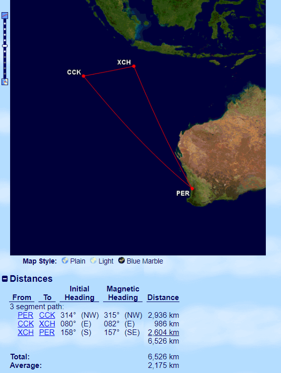
Virgin Australia operates the only flights to the Indian Ocean Territories from Perth. Source: http://www.gcmap.com/
Air

Virgin Airlines at Christmas Island airport.
The only way to arrive on Christmas Island is by flying.
Flights arrive at Christmas Island International Airport (IATA: XCH) which is located at an elevation of 279 metres (916 feet) above sea level, 5 km from the main population centre.
Passenger flights, which are operated by Virgin Australia, arrive twice a week on Tuesday and Friday. Virgin connect Perth to Christmas Island and Cocos (Keeling) Islands, flying a triangular circuit. The Tuesday flight operates in an anti-clockwise direction, calling first at Christmas Island, then continuing on to Cocos (Keeling) Islands, before returning to Perth, while the Friday flight operates in the opposite direction.

The terminal at Christmas Island airport.
All of this is subject to change at short notice with everything dependant on the, very unpredictable, tropical weather. Flights to the Indian Ocean territories are full of uncertainties. When travelling, you should purchase travel insurance, pack lots of patience, keep an open mind and bear in mind that if something can go wrong, it most probably will!
I spent two weeks visiting Christmas Island and Cocos (Keeling) Islands. It was two weeks of flight cancellations, flight changes and delays.
An added challenge is the distance and flight time involved, with the total flying time for the full circuit being 13 hours, which includes a 40-minute transit on each of the islands, during which all passengers must leave the aircraft.

My Christmas Island flight, displayed on the departure board at a very empty Perth International airport.
As per Australian Civil Aviation regulations, during one tour of duty, pilots are able to work a maximum of 8 hours, while cabin crew can work a maximum of 14 hours.
To satisfy these requirements, Virgin carry a 2nd pair of pilots on their flights, allowing 4 pilots to cover the 13-hour flying period. They also carry a mechanic, in case of any mechanical issue, since there are no aircraft mechanics based on the islands. Virgin carries just one flight crew.

Flights to Christmas Island depart from Perth International airport, which was empty due to the ongoing Covid pandemic.
In the event of a significant delay, the law requires Virgin to halt the flight so that the crew do not exceed their maximum allowed work hours. This happened on my flight from Christmas Island to Cocos (Keeling), where a technical issue led to a delay which resulted in the flight overnighting on Christmas Island.
The crew arrangement on this flight is very similar to that on the, equally epic, United Airlines’ Island Hopper (UA154), which I covered in my Central Pacific Island Hopper Guide.
Airport Transport
Airport transport can be arranged by calling the one taxi driver (Chris) at +61 (0)439 215 644 or through Indian Ocean Experiences who can be contacted at+61 (0) 439 215 667.
Getting Around

A road sign on Christmas Island.
Public Transport
There is no public transport on Christmas Island.
Taxi
There is one taxi on Christmas Island which is operated by Chris, who can be contacted at +61 (0)439 215 644.
Rental Car

My rental car and two Christmas Island red crabs.
With no public transport, the only sensible option for exploring this mountainous island is a rental car.
There are three rental agents on the island, all of whom are listed on the Car Rental page of the Christmas Island Visitor Centre website.

A Christmas Island License plate.
You can reserve your car from the visitor centre website, or directly from the agents listed here:
- Kiat Car Rental – Kiat car rental is owned by Jenny, who also owns the excellent CI Apartments accommodation complex in Poon Saan. With good, reliable, cars starting at $65 per day, Jenny’s cars tend to sell-out fast. You can email Jenny at kiat_tan@hotmail.com or telephone her on +61 (0) 439 215 388.
- Sea Eye Car Rental – offers a range of 2WD and 4WD cars from A$55 per day.
- Soong Car Rental – Another local of Chinese descent, Mr Soong, offers a range of clunkers which are best avoided. I hired through him as he was the only option available. My 4WD, which had about 250,000 kilometres on the odometer, included a slashed driver’s seat, bald tyres and was generally old, worn and very tired. Anywhere else, this car would have been scrapped long ago, however, on remote Christmas Island, such a relic is considered a viable rental option. During a trip to a more remote part of the island, one of the threadbare tires punctured. I then discovered the jack was broken which meant I needed assistance from Mr Soong who had to drive to the other side of the island to change my flat tyre.

A display of old Christmas Island License plates at the Tai Jin House museum.
Petrol Supply
There is just one petrol station on Christmas Island, which is operated by the Indian Ocean Oil Company. Located next to the CI Visitors Centre, a litre of unleaded petrol costs $A2.28. Filling up my Toyota rental car cost me A$114!
The station is open Monday to Friday from 9 am to 5 pm, on Saturday from 9 am to 1 pm and closed Sunday.
That’s the end of my travel guide for Christmas Island. I look forward to receiving feedback from anyone who uses this guide to plan a trip to Christmas Island.
Safe Travels!
Darren
Follow me on Instagram:
Further Reading
Following is a list of my travel reports from the Indian Ocean region:


.")


 which was issued without fuss at Moroni International Airport.")


 Islands.")

 Islands.")
 Islands.")


 Islands.")
 Islands, showing the circular shape of the barrier islands.")
 Islands.")
 Islands.")

 Islands.")

 Islands.")

 Islands license plate.")
 airport terminal on West Island.")
 Islands.")


 Islands.")
 above sea level, this concrete platform on South Island, marks the highest point on the Cocos (Keeling) Islands.")


 Islands.")


 Islands.")

 Islands flying on Home Island.")
 Islands.")
 Islands.")


 Islands.")


 Islands.")
 Islands.")

 Islands.")
 Islands.")
 Islands.")

 Islands.")

 Islands.")
 Islands.")


 Islands.")


 Islands.")
 Islands.")
 Islands.")
 Islands.")
 Islands.")


 Islands.")
 Islands.")
 Islands.")

 Islands.")


 Islands.")


 which passes beneath the vertical walls of the Cirque de Cilaos, providing access to the tiny hamlet of Îlet à Cordes.")


 inside the Cirque de Salazie provide a sense of scale for the towering walls which encircle the three cirques.")


 road to Cilaos.")


 coffee is passable!")


, with steep drop-offs on either side.")


 at Cafe de la Presse.")


